IMAGES TAKEN NEAR TO
Kents Green, GLOUCESTER, GL19 3AJ
Introduction
This page details the photographs taken nearby to Kents Green, GL19 3AJ by members of the Geograph project.
The Geograph project started in 2005 with the aim of publishing, organising and preserving representative images for every square kilometre of Great Britain, Ireland and the Isle of Man.

There are currently over 7.5m images from over14,400 individuals and you can help contribute to the project by visiting https://www.geograph.org.uk
Image Map
Images are licensed for reuse under creativecommons.org/licenses/by-sa/2.0
Notes
- Clicking on the map will re-center to the selected point.
- The higher the marker number, the further away the image location is from the centre of the postcode.
Image Listing (12 Images Found)
Images are licensed for reuse under creativecommons.org/licenses/by-sa/2.0
Image
Details
Distance
1
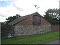
Barn at Stonehouse Farm
Built into the hillside.
Image: © Jonathan Thacker
Taken: 30 Jun 2011
0.03 miles
2
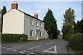
House on road junction at Kent's Green
Image: © Philip Halling
Taken: 9 Oct 2005
0.08 miles
3
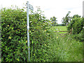
Footpath, Kent's Green
Skirting cottages west of the village.
Image: © Pauline E
Taken: 6 Jun 2008
0.08 miles
4
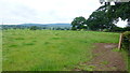
View to May Hill
Pastoral scene near Kent's Green.
Image: © Jonathan Billinger
Taken: 30 Jun 2016
0.13 miles
5
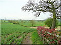
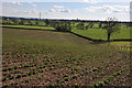
Farmland south of Kent's Green
The Photinia hedge forms the boundary of Five Elms Farm.
A public footpath runs between this and the field bean crop to the left.
Image: © Jonathan Billinger
Taken: 13 Apr 2011
0.14 miles
6
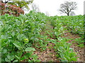
Detail of the field bean crop
Broad beans are grown widely for fodder purposes.
Here the seedlings of the previous year's rape crop are springing up between the rows.
Image: © Jonathan Billinger
Taken: 13 Apr 2011
0.14 miles
7
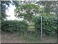
The beginning of the footpath from Five Elms Farm to Taynton church
Image: © Jonathan Thacker
Taken: 30 Jun 2011
0.15 miles
8
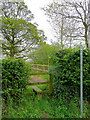
Footpath to Caerwents
The path from this stile heads north-west towards Newent.
Image: © Jonathan Billinger
Taken: 13 Apr 2011
0.17 miles
9
Arable land at Kent's Green
View across arable land at Kent's Green, Taynton Court Farm can be seen on the left in the middle distance.
Image: © Philip Halling
Taken: 13 Mar 2011
0.19 miles
10
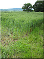
Wheat field, Kent's Green
Looking towards May Hill.
Image: © Pauline E
Taken: 6 Jun 2008
0.20 miles