IMAGES TAKEN NEAR TO
Tibberton Lane, GLOUCESTER, GL19 3AG
Introduction
This page details the photographs taken nearby to Tibberton Lane, GL19 3AG by members of the Geograph project.
The Geograph project started in 2005 with the aim of publishing, organising and preserving representative images for every square kilometre of Great Britain, Ireland and the Isle of Man.

There are currently over 7.5m images from over14,400 individuals and you can help contribute to the project by visiting https://www.geograph.org.uk
Image Map
Images are licensed for reuse under creativecommons.org/licenses/by-sa/2.0
Notes
- Clicking on the map will re-center to the selected point.
- The higher the marker number, the further away the image location is from the centre of the postcode.
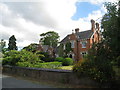
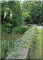
Image Listing (23 Images Found)
Images are licensed for reuse under creativecommons.org/licenses/by-sa/2.0
Image
Details
Distance
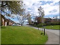
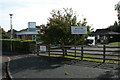
6
Orchard Rise, Tibberton
Looking west by Tibberton Primary School.
Image: © Jonathan Billinger
Taken: 15 May 2011
0.11 miles
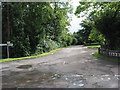
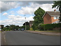
9
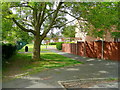
View from Orchard Rise
Looking south alongside the primary school, out of shot to the left.
Housing of Phelps Way to the right.
Image: © Jonathan Billinger
Taken: 15 May 2011
0.14 miles