IMAGES TAKEN NEAR TO
Huntley Road, GLOUCESTER, GL19 3AD
Introduction
This page details the photographs taken nearby to Huntley Road, GL19 3AD by members of the Geograph project.
The Geograph project started in 2005 with the aim of publishing, organising and preserving representative images for every square kilometre of Great Britain, Ireland and the Isle of Man.

There are currently over 7.5m images from over14,400 individuals and you can help contribute to the project by visiting https://www.geograph.org.uk
Image Map
Images are licensed for reuse under creativecommons.org/licenses/by-sa/2.0
Notes
- Clicking on the map will re-center to the selected point.
- The higher the marker number, the further away the image location is from the centre of the postcode.
Image Listing (10 Images Found)
Images are licensed for reuse under creativecommons.org/licenses/by-sa/2.0
Image
Details
Distance
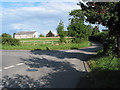
1
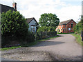
Grass field and Griffiths Farm, Tibberton
Image: © Jonathan Thacker
Taken: 22 Sep 2021
0.13 miles
2
Grass field, Tibberton
Near Griffins Farm.
Image: © Jonathan Thacker
Taken: 22 Sep 2021
0.15 miles
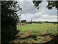
3
Harvested field near Birdsend
Looking west towards May Hill.
Image: © Pauline E
Taken: 17 Aug 2008
0.18 miles
5
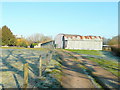
Poole Farm, Tibberton
Photo take from the public path on a frosty March morning.
Image: © Jonathan Billinger
Taken: 19 Mar 2011
0.20 miles
6
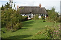
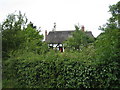
Thatched Cottage near Tibberton
Attractive thatched cottage near Tibberton.
Image: © Philip Halling
Taken: 9 Oct 2005
0.21 miles
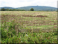
7
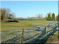
Pasture by Poole Farm
One of those distinctive views of May Hill in the distance.
Image: © Jonathan Billinger
Taken: 19 Mar 2011
0.21 miles
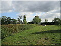
9
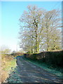
Farm track and footpath
Alongside Poole Farm, Tibberton.
Image: © Jonathan Billinger
Taken: 19 Mar 2011
0.22 miles