IMAGES TAKEN NEAR TO
Huntley Road, GLOUCESTER, GL19 3AB
Introduction
This page details the photographs taken nearby to Huntley Road, GL19 3AB by members of the Geograph project.
The Geograph project started in 2005 with the aim of publishing, organising and preserving representative images for every square kilometre of Great Britain, Ireland and the Isle of Man.

There are currently over 7.5m images from over14,400 individuals and you can help contribute to the project by visiting https://www.geograph.org.uk
Image Map
Images are licensed for reuse under creativecommons.org/licenses/by-sa/2.0
Notes
- Clicking on the map will re-center to the selected point.
- The higher the marker number, the further away the image location is from the centre of the postcode.
Image Listing (6 Images Found)
Images are licensed for reuse under creativecommons.org/licenses/by-sa/2.0
Image
Details
Distance
2
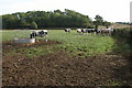
Livestock in a field near Tibberton
Cattle and a horse in a field opposite Morse's Farm near Tibberton.
Image: © Philip Halling
Taken: 9 Oct 2005
0.09 miles
3
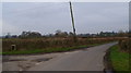
Wonky Telegraph Pole
Feeling the pressure of modern living.
Image: © David Robinson
Taken: 30 Nov 2008
0.11 miles
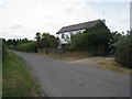
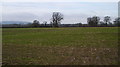
4
Morse's Farm in the distance
Pastoral scene north of the Huntley to Tibberton road.
Image: © Jonathan Billinger
Taken: 16 Feb 2011
0.17 miles
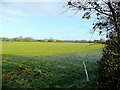
5
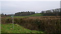
Field and coverts
Off the road from Tibberton to Huntley.
Image: © David Robinson
Taken: 30 Nov 2008
0.20 miles
6
Flat field near Tibberton
May Hill stands in the distance. There is an old hunt jump in the hedgerow at the centre of the picture.
Image: © David Robinson
Taken: 30 Nov 2008
0.23 miles