IMAGES TAKEN NEAR TO
Huntley Road, GLOUCESTER, GL19 3AA
Introduction
This page details the photographs taken nearby to Huntley Road, GL19 3AA by members of the Geograph project.
The Geograph project started in 2005 with the aim of publishing, organising and preserving representative images for every square kilometre of Great Britain, Ireland and the Isle of Man.

There are currently over 7.5m images from over14,400 individuals and you can help contribute to the project by visiting https://www.geograph.org.uk
Image Map
Images are licensed for reuse under creativecommons.org/licenses/by-sa/2.0
Notes
- Clicking on the map will re-center to the selected point.
- The higher the marker number, the further away the image location is from the centre of the postcode.
Image Listing (3 Images Found)
Images are licensed for reuse under creativecommons.org/licenses/by-sa/2.0
Image
Details
Distance
1
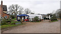
Christmas tree sales, 2
Trees sold at Prestbury Farm are grown here.
Image: © Jonathan Billinger
Taken: 6 Dec 2020
0.00 miles
2
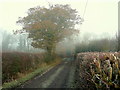
Prestbury Lane
A dead-end lane north of Huntley leading to Prestbury Farm.
The autumnal oak foliage has been frozen on.
Image: © Jonathan Billinger
Taken: 12 Dec 2010
0.14 miles
3
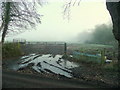
Frozen field entrance
Off Prestbury Lane on a cold frosty December morning.
Image: © Jonathan Billinger
Taken: 12 Dec 2010
0.15 miles