IMAGES TAKEN NEAR TO
Leddington, DYMOCK, GL18 2EG
Introduction
This page details the photographs taken nearby to GL18 2EG by members of the Geograph project.
The Geograph project started in 2005 with the aim of publishing, organising and preserving representative images for every square kilometre of Great Britain, Ireland and the Isle of Man.

There are currently over 7.5m images from over14,400 individuals and you can help contribute to the project by visiting https://www.geograph.org.uk
Image Map
Images are licensed for reuse under creativecommons.org/licenses/by-sa/2.0
Notes
- Clicking on the map will re-center to the selected point.
- The higher the marker number, the further away the image location is from the centre of the postcode.
Image Listing (10 Images Found)
Images are licensed for reuse under creativecommons.org/licenses/by-sa/2.0
Image
Details
Distance
1
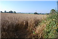
Oil Seed Rape field near Leddington
This is how the familiar yellow fields become when ready for harvest.
Image: © Julian P Guffogg
Taken: 10 Aug 2012
0.05 miles
2
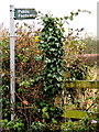
Double footpath sign
North on the Poet's Path number 2 and west towards Newhouse Bridge.
Image: © Jonathan Billinger
Taken: 21 Nov 2018
0.11 miles
3
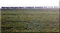
Sheep Pasture, Leddington
We had seen the sheep swirling and gathering when the hunt came near. Then as we walked along the Poet's Path they emerged on to our horizon with the sun behind like a scene from Zulu. I could think of no rhyme.
Image: © Bob Embleton
Taken: 26 Dec 2008
0.14 miles
4
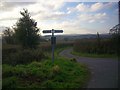
Road to Sneedfield
A minor road off a minor road. Links to the old Roman road from Leominster to Gloucester.
Image: © Bob Embleton
Taken: 26 Dec 2008
0.14 miles
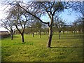
5
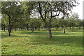
Mature apple orchard near Leddington
The apple orchard is to the rear of the farm at New House.
Image: © Philip Halling
Taken: 22 Oct 2005
0.15 miles
6
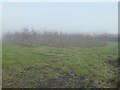
Apple orchard in mist
Herefordshire is famous for its cider making, this orchard no doubt produces apples for cider.
Image: © Philip Halling
Taken: 10 Jan 2018
0.18 miles
7
Path to Frogs Hall
Ploughed out and not reinstated.
http://www.defra.gov.uk/farm/environment/rights-of-way/index.htm
Image: © Bob Embleton
Taken: 26 Dec 2008
0.18 miles
8
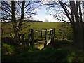
Footbridge on the Poet's Path
Crossing a minor tributary to the Preston Brook.
Image: © Bob Embleton
Taken: 26 Dec 2008
0.20 miles
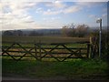
9
Orchard near New House
Taken from near the junction of the road from Sneedfield with the minor road linking to the old roman road.
Image: © Bob Embleton
Taken: 26 Dec 2008
0.20 miles
10
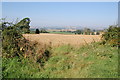
Crop Fields at Leddington
With the Cockshoot Hills in the distance.
Image: © Julian P Guffogg
Taken: 10 Aug 2012
0.20 miles