IMAGES TAKEN NEAR TO
DYMOCK, GL18 2EB
Introduction
This page details the photographs taken nearby to GL18 2EB by members of the Geograph project.
The Geograph project started in 2005 with the aim of publishing, organising and preserving representative images for every square kilometre of Great Britain, Ireland and the Isle of Man.

There are currently over 7.5m images from over14,400 individuals and you can help contribute to the project by visiting https://www.geograph.org.uk
Image Map
Images are licensed for reuse under creativecommons.org/licenses/by-sa/2.0
Notes
- Clicking on the map will re-center to the selected point.
- The higher the marker number, the further away the image location is from the centre of the postcode.
Image Listing (5 Images Found)
Images are licensed for reuse under creativecommons.org/licenses/by-sa/2.0
Image
Details
Distance
1
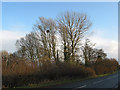
Clump of trees by the B5215
With single ball of mistletoe.
Image: © Pauline E
Taken: 2 Dec 2007
0.05 miles
2
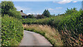
Lane from Hallwood Green
Looking east.
Image: © Jonathan Billinger
Taken: 9 Jul 2022
0.10 miles
3
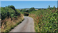
Lane to Hallwood Green
The hedges are being allowed to fill out this year.
Image: © Jonathan Billinger
Taken: 9 Jul 2022
0.11 miles
4
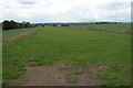
Airstrip near Dymock
This landing strip is beside the B4215 just north of Dymock.
Image: © Philip Halling
Taken: 22 Oct 2005
0.14 miles
5
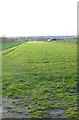
Footpath on grass landing strip
The strip is often used by trainee pilots carrying out 'practice forced landing' training.
Image: © Pauline E
Taken: 2 Dec 2007
0.23 miles