IMAGES TAKEN NEAR TO
Greenway, DYMOCK, GL18 2DX
Introduction
This page details the photographs taken nearby to GL18 2DX by members of the Geograph project.
The Geograph project started in 2005 with the aim of publishing, organising and preserving representative images for every square kilometre of Great Britain, Ireland and the Isle of Man.

There are currently over 7.5m images from over14,400 individuals and you can help contribute to the project by visiting https://www.geograph.org.uk
Image Map
Images are licensed for reuse under creativecommons.org/licenses/by-sa/2.0
Notes
- Clicking on the map will re-center to the selected point.
- The higher the marker number, the further away the image location is from the centre of the postcode.
Image Listing (4 Images Found)
Images are licensed for reuse under creativecommons.org/licenses/by-sa/2.0
Image
Details
Distance
1
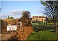
Bellamy's Farm
The site of George Bellamy's estate in the late 14th century. Its house, on a moated site entered from the north, was pulled down in the 18th century, apart from part of a wing added before 1739, and was later rebuilt. The farm buildings are to the north, outside the moat.
Image: © Bob Embleton
Taken: 26 Dec 2008
0.02 miles
2
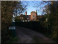
Greenway House
A moated site according to the O.S. map.
Image: © Bob Embleton
Taken: 26 Dec 2008
0.20 miles
3
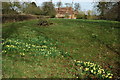
Greenway House
Greenway House viewed from the road to the west. Wild daffodils are in flower in the foreground.
Image: © Philip Halling
Taken: 15 Mar 2009
0.20 miles
4
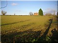
Blocked path near Upham
Attempting to walk from Greenway House to Upham, after the initial Public Footpath sign, we found nothing encouraging the walker: "Private Road", no waymark signs, a warning notice of CCTV then barbed wire.
Image: © Bob Embleton
Taken: 26 Dec 2008
0.21 miles