IMAGES TAKEN NEAR TO
Greenway, DYMOCK, GL18 2DT
Introduction
This page details the photographs taken nearby to GL18 2DT by members of the Geograph project.
The Geograph project started in 2005 with the aim of publishing, organising and preserving representative images for every square kilometre of Great Britain, Ireland and the Isle of Man.

There are currently over 7.5m images from over14,400 individuals and you can help contribute to the project by visiting https://www.geograph.org.uk
Image Map
Images are licensed for reuse under creativecommons.org/licenses/by-sa/2.0
Notes
- Clicking on the map will re-center to the selected point.
- The higher the marker number, the further away the image location is from the centre of the postcode.
Image Listing (15 Images Found)
Images are licensed for reuse under creativecommons.org/licenses/by-sa/2.0
Image
Details
Distance
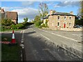
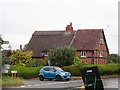
1
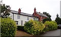
Houses set back from the B4216 at Greenway
Image: © Eirian Evans
Taken: 27 Jul 2019
0.01 miles
2
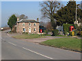
Telephone box and postbox at Greenway Crossroads
On the left, the county border sign, entering Herefordshire from Gloucestershire on the B4216 from Dymock to Ledbury.
Image: © Pauline E
Taken: 18 Feb 2008
0.03 miles
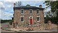
3
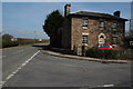
Stone House, Greenway Crossroads
With the name Stone house, this house just inside Gloucestershire is appropriately named. The sign to the left of the road in the background is the Herefordshire county boundary sign.
Image: © Philip Halling
Taken: 4 Apr 2008
0.03 miles
4
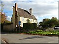
House at Greenway
Houses on the road junction at Greenway on the Gloucestershire and Herefordshire county boundary.
Image: © Philip Halling
Taken: 22 Oct 2020
0.03 miles
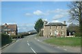
5
Road junction at Greenway
Houses on the junction on the B4216 at Greenway on the Gloucestershire and Herefordshire county boundary.
Image: © Philip Halling
Taken: 22 Oct 2020
0.03 miles
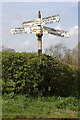
6
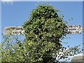
Direction Sign - Signpost on the B4216 at Greenway
Located on the southwest side of the crossroads on the B4216 at Greenway in Dymock parish. 4 arms and missing finial. Completely covered by ivy on Google Street View, November 2022. See also http://www.geograph.org.uk/photo/751689 and http://www.geograph.org.uk/photo/818580.
Milestone Society National ID: GL_SO7033
Image: © Roadside Relics
Taken: 13 Aug 2019
0.03 miles
7
Greenway crossroads
Looking northwards along the B4216.
Image: © Trevor Rickard
Taken: 4 Apr 2008
0.04 miles
8
Stone House
https://historicengland.org.uk/listing/the-list/list-entry/1155605?section=official-list-entry
Image: © Sandy Gerrard
Taken: 4 May 2024
0.04 miles
9
House on Greenway Cross
Maybe two houses, in fact. The crossroads is a stop on the Poets Path, a circular walk from Dymock
Image: © Eirian Evans
Taken: 27 Jul 2019
0.04 miles
10
Old signpost at Greenway, near Donnington
Old wooden signpost is just yards inside the county of Gloucestershire at the Greenway crossroads.
Image: © Philip Halling
Taken: 4 Apr 2008
0.04 miles