IMAGES TAKEN NEAR TO
Broomsgreen, DYMOCK, GL18 2DP
Introduction
This page details the photographs taken nearby to GL18 2DP by members of the Geograph project.
The Geograph project started in 2005 with the aim of publishing, organising and preserving representative images for every square kilometre of Great Britain, Ireland and the Isle of Man.

There are currently over 7.5m images from over14,400 individuals and you can help contribute to the project by visiting https://www.geograph.org.uk
Image Map
Images are licensed for reuse under creativecommons.org/licenses/by-sa/2.0
Notes
- Clicking on the map will re-center to the selected point.
- The higher the marker number, the further away the image location is from the centre of the postcode.
Image Listing (11 Images Found)
Images are licensed for reuse under creativecommons.org/licenses/by-sa/2.0
Image
Details
Distance
1
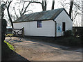
The Old Horseshoe Inn, Broom's Green
That's what the painted sign on the end of this building says and there are no arrows or other signs to point the way to something a little more pub-like. It looks as if trading has ceased.
Image: © Pauline E
Taken: 18 Feb 2008
0.03 miles
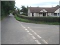
2
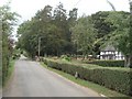
Broom's Green
View westwards along the straight village lane. Broom's Green Coppice to the right.
Image: © Trevor Rickard
Taken: 30 Aug 2007
0.05 miles
4
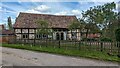
Barn at White's Farm
https://historicengland.org.uk/listing/the-list/list-entry/1078535?section=official-list-entry
Image: © Sandy Gerrard
Taken: 4 May 2024
0.08 miles
5
Lane junction at Broom's Green
Looking eastwards along the lane leading through the village. The village hall to the right as indicated by the lower sign!
Image: © Trevor Rickard
Taken: 30 Aug 2007
0.09 miles
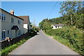
6
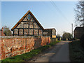
Lane from Broom's Green to Ryton
With timbered barn conversion and Dutch barn beyond. Laurel Farm is down this lane.
Image: © Pauline E
Taken: 18 Feb 2008
0.10 miles
7
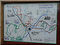
Daffodil Way and Poet's Way information board
By the village hall at Broom's Green.
Dymock is at the epicentre of these pleasant circular paths.
Image: © Jonathan Billinger
Taken: 5 Dec 2008
0.11 miles
8
Lane to Ryton
Looking south from Broom's Green.
Image: © Jonathan Billinger
Taken: 5 Dec 2008
0.12 miles
9
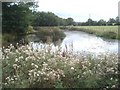
Pond south of Broom's Green
Looking south from near the footpath. Great crop of thistles.
Image: © Trevor Rickard
Taken: 30 Aug 2007
0.15 miles
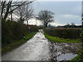
10
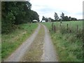
Track near Broom's Green
Looking southwards on the track from Donnington Hall to Broom's Green village. Broom's Green Coppice on the left.
Image: © Trevor Rickard
Taken: 30 Aug 2007
0.17 miles