IMAGES TAKEN NEAR TO
Bayfield Gardens, DYMOCK, GL18 2BH
Introduction
This page details the photographs taken nearby to Bayfield Gardens, GL18 2BH by members of the Geograph project.
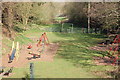
The Geograph project started in 2005 with the aim of publishing, organising and preserving representative images for every square kilometre of Great Britain, Ireland and the Isle of Man.

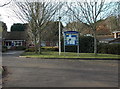
There are currently over 7.5m images from over14,400 individuals and you can help contribute to the project by visiting https://www.geograph.org.uk
Image Map
Images are licensed for reuse under creativecommons.org/licenses/by-sa/2.0
Notes
- Clicking on the map will re-center to the selected point.
- The higher the marker number, the further away the image location is from the centre of the postcode.
Image Listing (293 Images Found)
Images are licensed for reuse under creativecommons.org/licenses/by-sa/2.0
Image
Details
Distance
1
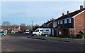
Bayfield Gardens houses, Dymock
Viewed from near the village school entrance. http://www.geograph.org.uk/photo/4031084
Image: © Jaggery
Taken: 8 Dec 2013
0.02 miles
2
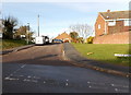
Bayfield Gardens, Dymock
Houses on the north side of Station Terrace.
Image: © Jaggery
Taken: 8 Dec 2013
0.03 miles
3
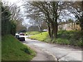
Collecting pupils from Ann Cam Primary School
The school is a short distance along the road (cul-de-sac) on the right.
Image: © David Smith
Taken: 15 Apr 2013
0.05 miles
4
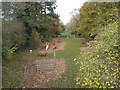
Route of dismantled railway, Dymock
Now a children's play area.
Image: © Pauline E
Taken: 9 Nov 2007
0.05 miles
5
Village school entrance, Dymock
The entrance to Ann Cam Church of England Primary School is from Bayfield Gardens.
The original 1825 school building is alongside the B4215. http://www.geograph.org.uk/photo/4030716
Image: © Jaggery
Taken: 8 Dec 2013
0.05 miles
6
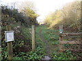
Permissive access route in Dymock
The information board states this short stretch of permissive access provides a new link between an existing village footpath and a children's playground. http://www.geograph.org.uk/photo/4054967 It follows the course of an old railway line known as The Daffodil Line, from Gloucester to Ledbury. Wild flowers are allowed to grow up and provide a haven for butterflies and other insects during the summer months.
Image: © Jaggery
Taken: 8 Dec 2013
0.05 miles
7
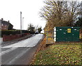
Danger - fragile roof, Dymock
The yellow danger notice is on the side of a telecoms cabinet near Ann Cam Primary School.
Image: © Jaggery
Taken: 8 Dec 2013
0.06 miles
8
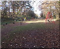
Children's play area in Dymock
Located on the route of the former Gloucester to Ledbury branch line near the site of demolished Dymock railway station.
Image: © Jaggery
Taken: 8 Dec 2013
0.06 miles
9
The course of the old railway line in Dymock
Image: © Roger Davies
Taken: 1 Apr 2012
0.07 miles
10
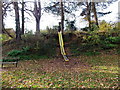
Yellow-edge slide in Dymock
Part of this http://www.geograph.org.uk/photo/4054967 children's play area.
Image: © Jaggery
Taken: 8 Dec 2013
0.07 miles