IMAGES TAKEN NEAR TO
Marcle Road, DYMOCK, GL18 2AR
Introduction
This page details the photographs taken nearby to Marcle Road, GL18 2AR by members of the Geograph project.
The Geograph project started in 2005 with the aim of publishing, organising and preserving representative images for every square kilometre of Great Britain, Ireland and the Isle of Man.

There are currently over 7.5m images from over14,400 individuals and you can help contribute to the project by visiting https://www.geograph.org.uk
Image Map
Images are licensed for reuse under creativecommons.org/licenses/by-sa/2.0
Notes
- Clicking on the map will re-center to the selected point.
- The higher the marker number, the further away the image location is from the centre of the postcode.
Image Listing (6 Images Found)
Images are licensed for reuse under creativecommons.org/licenses/by-sa/2.0
Image
Details
Distance
1
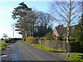
B4024 at Hill Grove
Looking west towards Much Marcle.
The pine trees indicate the location of the house named on mapping.
Image: © Jonathan Billinger
Taken: 5 Dec 2008
0.05 miles
2
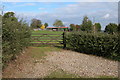
Stable and Paddock at Hill Grove near Dymock
Image: © Philip Halling
Taken: 22 Oct 2005
0.09 miles
3
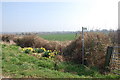
Countryside with daffodils near Hill Grove
Image: © Julian P Guffogg
Taken: 21 Mar 2009
0.13 miles
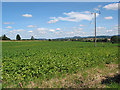
4
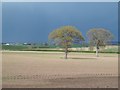
A big field
By Windcross, Dymock. The oaks remain from a lost hedgerow.
Image: © Richard Webb
Taken: 14 Apr 2016
0.17 miles
5
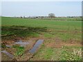
Great Netherton Farm
View over farmland to the farms of Great Netherton Farm in the middle distance on the left, and Rose Hill Farm is on the right in the distance. Great-grandparents of mine rent both these farms in the late 19th century.
Image: © Philip Halling
Taken: 30 Mar 2021
0.19 miles