IMAGES TAKEN NEAR TO
Leominster Road, DYMOCK, GL18 2AN
Introduction
This page details the photographs taken nearby to Leominster Road, GL18 2AN by members of the Geograph project.
The Geograph project started in 2005 with the aim of publishing, organising and preserving representative images for every square kilometre of Great Britain, Ireland and the Isle of Man.

There are currently over 7.5m images from over14,400 individuals and you can help contribute to the project by visiting https://www.geograph.org.uk
Image Map
Images are licensed for reuse under creativecommons.org/licenses/by-sa/2.0
Notes
- Clicking on the map will re-center to the selected point.
- The higher the marker number, the further away the image location is from the centre of the postcode.
Image Listing (17 Images Found)
Images are licensed for reuse under creativecommons.org/licenses/by-sa/2.0
Image
Details
Distance
1
Daffodil Way at Shakesfield
Looking north-west up Leominster Road from the point where the Daffodil Way emerges from the Old Road.
Image: © Trevor Rickard
Taken: 4 Apr 2008
0.02 miles
2
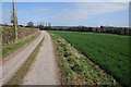
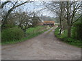
Daffodil Way near Shakesfield
Daffodil Way near Shakesfield following a farm road to Allum's Farm near Dymock.
Image: © Philip Halling
Taken: 22 Mar 2015
0.14 miles
3
Daffodil Way heading for Shakesfield
Looking eastwards on the track from Allum's Farm.
Image: © Trevor Rickard
Taken: 4 Apr 2008
0.15 miles
4
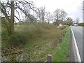
Herefordshire and Gloucestershire Canal
A recognisable stretch of canal beside Leominster Road, north of Dymock.
Image: © Richard Webb
Taken: 14 Apr 2016
0.16 miles
5
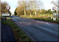
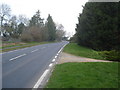
Thank you for driving carefully in Dymock
The 30mph speed limit along the B4215 increases to 40mph beyond the northern boundary http://www.geograph.org.uk/photo/4030922 of the village.
Image: © Jaggery
Taken: 8 Dec 2013
0.16 miles
6
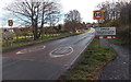
Northern boundary of Dymock
The 40mph speed limit along the B4215 reduces to 30mph in Dymock,
a village in NW Gloucestershire, in the Forest of Dean district.
Image: © Jaggery
Taken: 8 Dec 2013
0.17 miles
7
The Daffodil Way at the Entrance to Maypole Farm
Looking eastwards across the Leadon valley from the old road, which is now the route for the Daffodil Way. Next door is Harmony Cottage. Nice names!
Image: © Trevor Rickard
Taken: 4 Apr 2008
0.17 miles
8
Entrance to Dymock Grange Golf Club
Opened in 1995, this enjoys a lovely setting with beautiful scenery all around.
Image: © Pauline E
Taken: 19 Dec 2007
0.18 miles
9
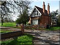
Lodge at entrance to Dymock Golf Club
Lodge at the entrance to Dymock Grange Golf and Country Club.
Image: © Philip Halling
Taken: 30 Mar 2021
0.18 miles
10
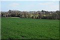
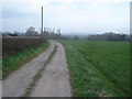
Dymock viewed from the north-west
Dymock viewed from the Daffodil Way near Shakesfield to the north-west.
Image: © Philip Halling
Taken: 22 Mar 2015
0.20 miles