IMAGES TAKEN NEAR TO
DYMOCK, GL18 2AD
Introduction
This page details the photographs taken nearby to GL18 2AD by members of the Geograph project.
The Geograph project started in 2005 with the aim of publishing, organising and preserving representative images for every square kilometre of Great Britain, Ireland and the Isle of Man.

There are currently over 7.5m images from over14,400 individuals and you can help contribute to the project by visiting https://www.geograph.org.uk
Image Map
Images are licensed for reuse under creativecommons.org/licenses/by-sa/2.0
Notes
- Clicking on the map will re-center to the selected point.
- The higher the marker number, the further away the image location is from the centre of the postcode.
Image Listing (20 Images Found)
Images are licensed for reuse under creativecommons.org/licenses/by-sa/2.0
Image
Details
Distance
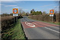
1
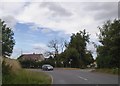
Bend and road junction near The Pound, Dymock
Image: © David Smith
Taken: 3 Aug 2018
0.08 miles
4
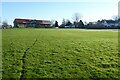
Dymock cricket field
The Poet's Path No.1, a recreational wlaking path crosses Dymock's cricket field.
Image: © Philip Halling
Taken: 13 Jan 2022
0.09 miles

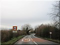
7

Entering Dymock
On the B4215 road northbound.
Image: © J.Hannan-Briggs
Taken: 13 Oct 2016
0.10 miles
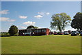
8
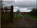
Dymock Cricket Club home ground
Off Crowfield Lane, east of the village.
Image: © Eirian Evans
Taken: 4 Dec 2011
0.13 miles
9
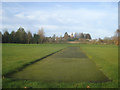
Straight drive to St Mary's
The artificial pitch is part of the square at Dymock cricket ground. The batsman would have a good view to St Mary's and Dymock village.
Image: © Trevor Rickard
Taken: 19 Nov 2008
0.15 miles
10
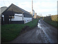
Farm buildings at The Pound
View west along the narrow access lane.
Image: © Trevor Rickard
Taken: 19 Nov 2008
0.16 miles