IMAGES TAKEN NEAR TO
Knowles Road, NEWENT, GL18 1TZ
Introduction
This page details the photographs taken nearby to Knowles Road, GL18 1TZ by members of the Geograph project.
The Geograph project started in 2005 with the aim of publishing, organising and preserving representative images for every square kilometre of Great Britain, Ireland and the Isle of Man.

There are currently over 7.5m images from over14,400 individuals and you can help contribute to the project by visiting https://www.geograph.org.uk
Image Map
Images are licensed for reuse under creativecommons.org/licenses/by-sa/2.0
Notes
- Clicking on the map will re-center to the selected point.
- The higher the marker number, the further away the image location is from the centre of the postcode.
Image Listing (56 Images Found)
Images are licensed for reuse under creativecommons.org/licenses/by-sa/2.0
Image
Details
Distance
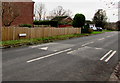
1
Towards Drovers Way and Meadow Grove, Newent
From Foley Road looking towards recently-built houses in December 2015.
Image: © Jaggery
Taken: 28 Dec 2015
0.07 miles
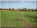
2
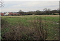
Muddy track into a field, Newent
From Foley Road viewed in late December 2015.
Image: © Jaggery
Taken: 28 Dec 2015
0.08 miles
3
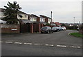
283-278 Foley Road, Newent
One of many side arms of Foley Road at right angles to the main course of the road. This one is on the east side.
Image: © Jaggery
Taken: 28 Dec 2015
0.09 miles
4
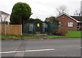
Foley Road electricity substation, Newent
The Western Power Distribution electricity substation identifier is FOLEY ROAD S/S 41227
Image: © Jaggery
Taken: 28 Dec 2015
0.10 miles
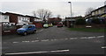
5
Foley Road speed bumps, Newent
The sign behind the bumps points right towards 336-313 Foley Road.
Image: © Jaggery
Taken: 28 Dec 2015
0.11 miles
6
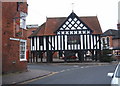
Market Hall, Newent
This photograph was taken 24th December 2006. It is taken from Church Street.
Image: © Diane Rawlings
Taken: 24 Dec 2006
0.11 miles
7

Newent Parish Church
The parish church of Saint Mary's at Newent dates back to Norman times.
The church has a huge spire which is not shown from this angle
Image: © Stephen Nunney
Taken: Unknown
0.11 miles
8
An eastern arm of Foley Road, Newent
One of many side arms of Foley Road at right angles to the main course of the road.
This one contains 256-250 Foley Road on the left and 272A-277 Foley Road on the right.
Image: © Jaggery
Taken: 28 Dec 2015
0.11 miles
9
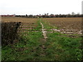
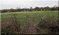
Public footpath north through a field, Newent
The narrow track is a public footpath, viewed from Southend Lane.
Image: © Jaggery
Taken: 28 Dec 2015
0.12 miles
10
Well-used footpath into Newent
Leading almost due north towards the town centre.
Image: © Pauline E
Taken: 1 Feb 2008
0.13 miles