IMAGES TAKEN NEAR TO
Court Road, NEWENT, GL18 1SN
Introduction
This page details the photographs taken nearby to Court Road, GL18 1SN by members of the Geograph project.
The Geograph project started in 2005 with the aim of publishing, organising and preserving representative images for every square kilometre of Great Britain, Ireland and the Isle of Man.

There are currently over 7.5m images from over14,400 individuals and you can help contribute to the project by visiting https://www.geograph.org.uk
Image Map
Images are licensed for reuse under creativecommons.org/licenses/by-sa/2.0
Notes
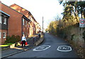
- Clicking on the map will re-center to the selected point.
- The higher the marker number, the further away the image location is from the centre of the postcode.
Image Listing (142 Images Found)
Images are licensed for reuse under creativecommons.org/licenses/by-sa/2.0
Image
Details
Distance
1
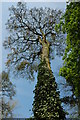
Tree beside Newent Lake
Tall tree on the south bank of Newent Lake.
Image: © Philip Halling
Taken: 18 Apr 2009
0.02 miles
2
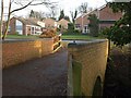
Footbridge, Newent
The brick bridge carries a path between Newent Lake and Court Road across a small watercourse taken off the Ell Brook.
Image: © Derek Harper
Taken: 2 Feb 2010
0.04 miles
3
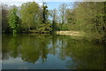
Newent Lake
The eastern end of Newent Lake
Image: © Philip Halling
Taken: 18 Apr 2009
0.05 miles
4
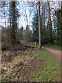
Footbridge at east end of Newent Lake
Part of the round-the-lake footpath
Image: © David Smith
Taken: 15 Apr 2013
0.06 miles
5
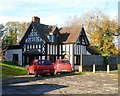
East Lodge, Newent
The black-and-white house is set back from the north side of Gloucester Street.
Image: © Jaggery
Taken: 13 Nov 2011
0.07 miles
6
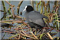
A coot on Newent Lake
A coot (Fulica atra) on the shore of Newent Lake.
Image: © Philip Halling
Taken: 18 Apr 2009
0.08 miles
7
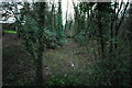
Dry canal bed, Newent
The bed of the old Gloucester - Hereford canal. This canal was opened in stages, between 1795 and 1845, at a cost almost exactly double the original estimates. For various reasons - lack of projected coal traffic and unexpected construction costs (particularly relating to the two tunnels on the route) - the canal never really made any money, and the company almost immediately entered negotiations with the Great Western Railway to purchase the canal with a view to converting it to a railway. This the GWR did in 1881, closing the southern half of the canal for the purpose. Much of the route was converted; however, odd bits never were, and this is one of them.
Image: © John Winder
Taken: 23 Jan 2010
0.08 miles
8
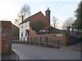
House on Gloucester Street, Newent
A raised pavement and a brick wall are outside The White House, which must have been on the very edge of Newent before the Cleeve Mill estate extended the town eastwards.
Image: © Derek Harper
Taken: 2 Feb 2010
0.09 miles
9
Slightly elevated pavement, Gloucester Street, Newent
There are buildings on only one side of the street here.
Image: © Jaggery
Taken: 13 Nov 2011
0.09 miles
10
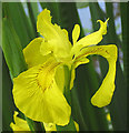
The flags are out
Yellow iris - Iris pseudacorus, also known as yellow flag. Has large, yellow, purple-veined flowers and flattened sprays of sword-shaped leaves.
Image: © Pauline E
Taken: 6 Jun 2008
0.10 miles