1
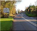
NEWENT - Please drive carefully
The National Speed Limit on Horsefair Lane drops to 30mph.
Image: © Jaggery
Taken: 9 Apr 2023
0.08 miles
2
Old Council Yard and Horsefair Wharf, Newent
Located on the north side of Horsefair Lane. A sign on the left shows Old Council Yard.
A Herefordshire and Gloucestershire Canal Trust sign on the right shows
HORSEFAIR WHARF
PLEASE KEEP GATES CLEAR
24 HOUR ACCESS.
Image: © Jaggery
Taken: 13 Nov 2011
0.09 miles
3
Cattle grazing on sloping ground, Newent
Viewed from Horsefair Lane.
Image: © Jaggery
Taken: 13 Nov 2011
0.09 miles
4
Crossing Ell Brook
Work in progress on the restoration of Ell Brook Aqueduct.
Image: © Pauline E
Taken: 27 Jan 2008
0.12 miles
5
Mantley, Newent
The mid to late C18 farmhouse has a sundial at the base of the nearer chimney stack. The listed building description notes that it "forms an unusually complete group with contemporary or older farm buildings" http://www.imagesofengland.org.uk/details/default.aspx?id=125706 .
Image: © Derek Harper
Taken: 2 Feb 2010
0.12 miles
6
Grade II listed Mantley House, Newent
Viewed across Ross Road. Mantley House is a farmhouse built in 1761, extended in 1776.
The sundial on the chimney stack on the left was added in 1777, restored in 1894.
Grade II listed in October 1985.
Image: © Jaggery
Taken: 13 Nov 2011
0.12 miles
7
Western boundary of Newent
The B4221 Ross Road reaches the western boundary of Newent, a small market town at the northern edge of the Forest of Dean in north Gloucestershire. Newent's population was 5,073 at the 2001 census.
Image: © Jaggery
Taken: 13 Nov 2011
0.13 miles
8
Cotswold Oak / Noent Edge at Newent boards, Gloucestershire
On the corner of Bradfords Lane and the B4221 Ross Road in April 2023.
Image: © Jaggery
Taken: 9 Apr 2023
0.13 miles
9
Bus shelter, Ross Road, Picklenash, Newent
Image: © David Smith
Taken: 3 Aug 2018
0.14 miles
10
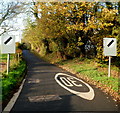
End of 30mph speed limit in Newent
A view west along Horsefair Lane where the 30mph speed limit in Newent
increases to the National Speed Limit ahead.
Image: © Jaggery
Taken: 13 Nov 2011
0.14 miles


