IMAGES TAKEN NEAR TO
Newlands Court, Foley Road, NEWENT, GL18 1RY
Introduction
This page details the photographs taken nearby to Newlands Court, Foley Road, GL18 1RY by members of the Geograph project.
The Geograph project started in 2005 with the aim of publishing, organising and preserving representative images for every square kilometre of Great Britain, Ireland and the Isle of Man.

There are currently over 7.5m images from over14,400 individuals and you can help contribute to the project by visiting https://www.geograph.org.uk
Image Map
Images are licensed for reuse under creativecommons.org/licenses/by-sa/2.0
Notes
- Clicking on the map will re-center to the selected point.
- The higher the marker number, the further away the image location is from the centre of the postcode.
Image Listing (49 Images Found)
Images are licensed for reuse under creativecommons.org/licenses/by-sa/2.0
Image
Details
Distance
2
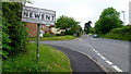
Welcome to Newent
The slate sign on the left is located alongside Gloucester Street near the eastern boundary of Newent, between the corner of Onslow Road and a bus stop. An older boundary sign http://www.geograph.org.uk/photo/2979599 is a fewer metres behind the camera.
Image: © Jaggery
Taken: 13 Nov 2011
0.05 miles
3
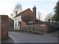
House on Gloucester Street, Newent
A raised pavement and a brick wall are outside The White House, which must have been on the very edge of Newent before the Cleeve Mill estate extended the town eastwards.
Image: © Derek Harper
Taken: 2 Feb 2010
0.07 miles
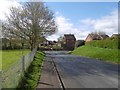
4
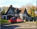
East Lodge, Newent
The black-and-white house is set back from the north side of Gloucester Street.
Image: © Jaggery
Taken: 13 Nov 2011
0.07 miles
5
Old Newent town sign
The pre-Worboys sign on Gloucester Road is showing its age as the Dymock 3&3/4 miles is almost invisible. There are two more town signs within a few metres of this one - the slate millennium version can be seen up ahead.
Image: © Jonathan Billinger
Taken: 31 May 2012
0.08 miles
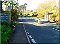
6
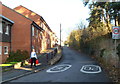
Slightly elevated pavement, Gloucester Street, Newent
There are buildings on only one side of the street here.
Image: © Jaggery
Taken: 13 Nov 2011
0.09 miles
7
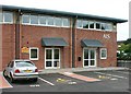
New industrial units at Newent Business Park
AIS Ltd arrived at Newent Business Park in 2004.
Image: © Ken Ballinger
Taken: 10 Aug 2005
0.10 miles
8
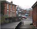
Gloucester Street, Newent
The first of a pair of sharp bends that takes the old road from Gloucester into Church Street and the town centre. The Town House on the left is raised well above street level. The modern house in the background is part of St Bartholomews, a sheltered housing development.
Image: © Derek Harper
Taken: 2 Feb 2010
0.15 miles
9
Ross Willis Court, Newent
Viewed across Gloucester Street.
A metal plaque on the building records:
THE ROYAL BRITISH LEGION HOUSING ASSOCIATION LIMITED
THESE FLATS WERE OPENED ON 15TH JUNE 1979
BY HRH THE PRINCESS ANNE, MRS MARK PHILLIPS GCVO.
Image: © Jaggery
Taken: 13 Nov 2011
0.15 miles
10
Newent Osteopaths
Established by Sue Eden in 1989, Newent Osteopaths are located
in The Coach House, set back from Gloucester Street.
Image: © Jaggery
Taken: 13 Nov 2011
0.16 miles