IMAGES TAKEN NEAR TO
School View, NEWENT, GL18 1RX
Introduction
This page details the photographs taken nearby to School View, GL18 1RX by members of the Geograph project.
The Geograph project started in 2005 with the aim of publishing, organising and preserving representative images for every square kilometre of Great Britain, Ireland and the Isle of Man.

There are currently over 7.5m images from over14,400 individuals and you can help contribute to the project by visiting https://www.geograph.org.uk
Image Map
Images are licensed for reuse under creativecommons.org/licenses/by-sa/2.0
Notes
- Clicking on the map will re-center to the selected point.
- The higher the marker number, the further away the image location is from the centre of the postcode.
Image Listing (54 Images Found)
Images are licensed for reuse under creativecommons.org/licenses/by-sa/2.0
Image
Details
Distance
1
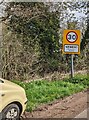
NEWENT - Please drive carefully
The National Speed Limit on Horsefair Lane drops to 30mph.
Image: © Jaggery
Taken: 9 Apr 2023
0.09 miles
2
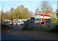
Old Council Yard and Horsefair Wharf, Newent
Located on the north side of Horsefair Lane. A sign on the left shows Old Council Yard.
A Herefordshire and Gloucestershire Canal Trust sign on the right shows
HORSEFAIR WHARF
PLEASE KEEP GATES CLEAR
24 HOUR ACCESS.
Image: © Jaggery
Taken: 13 Nov 2011
0.10 miles
3
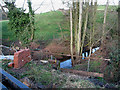
Crossing Ell Brook
Work in progress on the restoration of Ell Brook Aqueduct.
Image: © Pauline E
Taken: 27 Jan 2008
0.12 miles
4
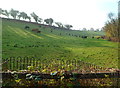
Cattle grazing on sloping ground, Newent
Viewed from Horsefair Lane.
Image: © Jaggery
Taken: 13 Nov 2011
0.13 miles
5
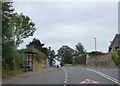
Bus shelter, Ross Road, Picklenash, Newent
Image: © David Smith
Taken: 3 Aug 2018
0.14 miles
6
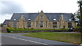
Primary school building, Newent
The oldest section of Glebe Infant and Picklenash Junior School, Newent.
Image: © Jonathan Billinger
Taken: 5 Aug 2015
0.15 miles
7
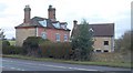
Mantley, Newent
The mid to late C18 farmhouse has a sundial at the base of the nearer chimney stack. The listed building description notes that it "forms an unusually complete group with contemporary or older farm buildings" http://www.imagesofengland.org.uk/details/default.aspx?id=125706 .
Image: © Derek Harper
Taken: 2 Feb 2010
0.15 miles
8
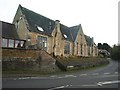
Picklenash Court, Newent
This stone building stands at the junction of Bradfords Lane and Ross Road (foreground).
Image: © Derek Harper
Taken: 2 Feb 2010
0.15 miles
9
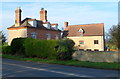
Grade II listed Mantley House, Newent
Viewed across Ross Road. Mantley House is a farmhouse built in 1761, extended in 1776.
The sundial on the chimney stack on the left was added in 1777, restored in 1894.
Grade II listed in October 1985.
Image: © Jaggery
Taken: 13 Nov 2011
0.15 miles
10
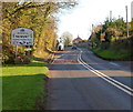
Western boundary of Newent
The B4221 Ross Road reaches the western boundary of Newent, a small market town at the northern edge of the Forest of Dean in north Gloucestershire. Newent's population was 5,073 at the 2001 census.
Image: © Jaggery
Taken: 13 Nov 2011
0.16 miles