IMAGES TAKEN NEAR TO
Oxenhall, NEWENT, GL18 1RJ
Introduction
This page details the photographs taken nearby to GL18 1RJ by members of the Geograph project.
The Geograph project started in 2005 with the aim of publishing, organising and preserving representative images for every square kilometre of Great Britain, Ireland and the Isle of Man.

There are currently over 7.5m images from over14,400 individuals and you can help contribute to the project by visiting https://www.geograph.org.uk
Image Map
Images are licensed for reuse under creativecommons.org/licenses/by-sa/2.0
Notes
- Clicking on the map will re-center to the selected point.
- The higher the marker number, the further away the image location is from the centre of the postcode.
Image Listing (18 Images Found)
Images are licensed for reuse under creativecommons.org/licenses/by-sa/2.0
Image
Details
Distance
1
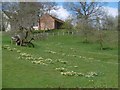
Daffodils, White House
Orchard in the daffodil country surrounding Dymock.
Image: © Richard Webb
Taken: 16 Apr 2016
0.04 miles
2

Cowslips by the lane side, 2
Close up of the Primula veris in Image
Image: © Jonathan Billinger
Taken: 30 Apr 2015
0.04 miles
3

Cowslips by the lane side, 1
A sheltered spot on a steep bank by Whitehouse Lane.
Image: © Jonathan Billinger
Taken: 30 Apr 2015
0.04 miles
4
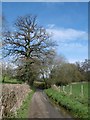
Hawthorne Hill
Narrow lane between Gorsley and Newent.
Image: © Richard Webb
Taken: 16 Apr 2016
0.07 miles
6
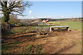
Sheep pasture near Gorsley in early April
View looks westwards across sheep pasture from a point near White House farm. In the background are the trees of Hay Wood.
Image: © Roger Davies
Taken: 8 Apr 2008
0.11 miles
7
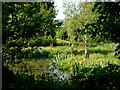
Pond alongside Whitehouse Lane, 1
A peaceful spring scene with the top of May Hill glimpsed in the distance.
Image: © Jonathan Billinger
Taken: 7 May 2015
0.12 miles
8
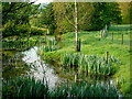
Pond alongside Whitehouse Lane, 2
One month on from Image and the Flag Irises are golden in the early June, early morning sunshine.
Image: © Jonathan Billinger
Taken: 3 Jun 2015
0.12 miles
9
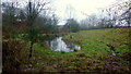
Pond alongside Whitehouse Lane, 3
Image: © Jonathan Billinger
Taken: 23 Dec 2016
0.12 miles
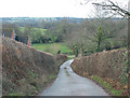
10
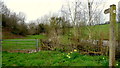
Footpath south from Whitehouse Lane
An artificial pond to the right and the path, part of the Three Choirs Way LDF crosses rolling landscape towards Kilcot.
Image: © Jonathan Billinger
Taken: 4 Apr 2015
0.12 miles