IMAGES TAKEN NEAR TO
Knights Way, NEWENT, GL18 1QJ
Introduction
This page details the photographs taken nearby to Knights Way, GL18 1QJ by members of the Geograph project.
The Geograph project started in 2005 with the aim of publishing, organising and preserving representative images for every square kilometre of Great Britain, Ireland and the Isle of Man.

There are currently over 7.5m images from over14,400 individuals and you can help contribute to the project by visiting https://www.geograph.org.uk
Image Map
Images are licensed for reuse under creativecommons.org/licenses/by-sa/2.0
Notes
- Clicking on the map will re-center to the selected point.
- The higher the marker number, the further away the image location is from the centre of the postcode.
Image Listing (24 Images Found)
Images are licensed for reuse under creativecommons.org/licenses/by-sa/2.0
Image
Details
Distance
1
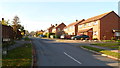
The Tythings, Newent
Residential street viewed from the Watery Lane end.
Image: © Jaggery
Taken: 13 Nov 2011
0.07 miles
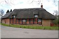
2
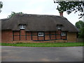
Thatched building on Bradford's Lane, Newent
The rear of a nice thatched cottage.
Image: © Jeremy Bolwell
Taken: 27 Aug 2012
0.11 miles
3
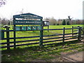
Broadford Meadow Arboretum
A Millennium Project-aided facility off Bradford's Lane to the west of Newent.
Image: © Jonathan Billinger
Taken: 6 Mar 2009
0.11 miles
4
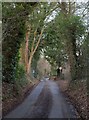
Bradfords Lane, Newent
This old lane on the west side of Newent now encloses the built-up area (right); it seems inevitable that it will itself be enclosed within further development at some stage.
Image: © Derek Harper
Taken: 2 Feb 2010
0.11 miles
5
Bradfords Cottage
An early 17th century timber-framed thatched cottage just outside Newent. The cottage is Grade II listed, see: https://historicengland.org.uk/listing/the-list/list-entry/1172282?section=official-list-entry
Image: © Philip Halling
Taken: 3 Apr 2022
0.12 miles
6
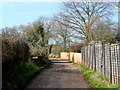
Elmcroft Lane
Leading west from Bradford's Lane; this lane is publicly accessible on foot only.
Image: © Jonathan Billinger
Taken: 6 Mar 2009
0.13 miles
7
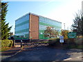
Northern corner of Newent Community School
Viewed from Watery Lane.
Newent Community School and Sixth Form Centre was Gloucestershire’s first purpose-built comprehensive school. It opened in April 1965. Nearly half a century later, it is now a Foundation School serving the town of Newent and the surrounding rural community. There are about 1300 students enrolled.
Image: © Jaggery
Taken: 13 Nov 2011
0.16 miles
8
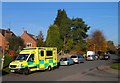
Emergency ambulance, Watery Lane, Newent
Viewed from the entrance to Newent Community School. http://www.geograph.org.uk/photo/2693734
The ambulance is part of the Great Western Ambulance Service (GWAS), a National Health Service Trust. GWAS provides accident & emergency (999) and urgent care; patient transport service; out-of-hours service (in Gloucestershire). The areas covered are: Bath and North East Somerset; Bristol; Gloucestershire; Wiltshire; North Somerset; Swindon (including Watchfield and Shrivenham).
Image: © Jaggery
Taken: 13 Nov 2011
0.16 miles
9
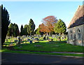
Newent Cemetery
Viewed from the Watery Lane side of the cemetery, near the edge of a cemetery chapel. http://www.geograph.org.uk/photo/2693761
The cemetery opened in 1864.
Image: © Jaggery
Taken: 13 Nov 2011
0.16 miles
10
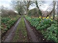
Daffodils along track
Lots of daffodils alongside a dirt track leading towards Newent.
Image: © Pebble
Taken: 18 Mar 2023
0.16 miles