IMAGES TAKEN NEAR TO
Mill Lane, NEWENT, GL18 1NU
Introduction
This page details the photographs taken nearby to Mill Lane, GL18 1NU by members of the Geograph project.
The Geograph project started in 2005 with the aim of publishing, organising and preserving representative images for every square kilometre of Great Britain, Ireland and the Isle of Man.

There are currently over 7.5m images from over14,400 individuals and you can help contribute to the project by visiting https://www.geograph.org.uk
Image Map
Images are licensed for reuse under creativecommons.org/licenses/by-sa/2.0
Notes
- Clicking on the map will re-center to the selected point.
- The higher the marker number, the further away the image location is from the centre of the postcode.
Image Listing (17 Images Found)
Images are licensed for reuse under creativecommons.org/licenses/by-sa/2.0
Image
Details
Distance
1
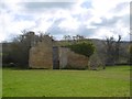
Farm building off Mill Lane
Old sandstone building in what was an orchard.
Image: © Richard Webb
Taken: 16 Apr 2016
0.06 miles
2
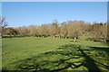
A tree monster?
View looks westwards from a lane near Little Gorsley across a paddock. Willow trees follow the course of a small brook. The early morning sun has cast a shadow of an oak tree looking a bit like a giant triffid over the paddock.
Image: © Roger Davies
Taken: 15 Apr 2008
0.11 miles
3
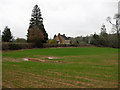
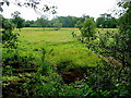
Waterlogged field
Arable land south of Mill Lane, Little Gorsley.
Image: © Pauline E
Taken: 1 Mar 2011
0.16 miles
4
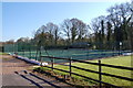
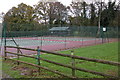
Aston Ingham tennis club in April with sand bags
View looks northwards with the tennis court highlighted by the early morning sun. Sand bags still adorn the perimeter after winter flooding.
Image: © Roger Davies
Taken: 15 Apr 2008
0.17 miles
5

Wildflower meadow
With Common Spotted Orchids, Dactylorhiza fuchsii, well to the fore.
Image: © Jonathan Billinger
Taken: 22 Jun 2008
0.17 miles
6
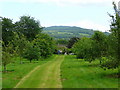
View across meadows
On the west side of the Ell Brook in West Gloucestershire.
Image: © Jonathan Billinger
Taken: 22 Jun 2008
0.19 miles
8
Orchard with a view
On the boundary of Gloucestershire and Herefordshire looking towards May Hill.
Image: © Jonathan Billinger
Taken: 22 Jun 2008
0.19 miles
9
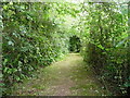
Footpath tunnel
This right-of-way leads from Ford lane to the B4222.
Image: © Jonathan Billinger
Taken: 22 Jun 2008
0.19 miles
