IMAGES TAKEN NEAR TO
Oxenhall, NEWENT, GL18 1LX
Introduction
This page details the photographs taken nearby to GL18 1LX by members of the Geograph project.
The Geograph project started in 2005 with the aim of publishing, organising and preserving representative images for every square kilometre of Great Britain, Ireland and the Isle of Man.

There are currently over 7.5m images from over14,400 individuals and you can help contribute to the project by visiting https://www.geograph.org.uk
Image Map
Images are licensed for reuse under creativecommons.org/licenses/by-sa/2.0
Notes
- Clicking on the map will re-center to the selected point.
- The higher the marker number, the further away the image location is from the centre of the postcode.
Image Listing (6 Images Found)
Images are licensed for reuse under creativecommons.org/licenses/by-sa/2.0
Image
Details
Distance
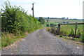
3
Holders Lane - Hillend Green, Gloucestershire
A view on Holders Lane in the scattered village of Hillend Green in Gloucestershire. It lies to the north of Newent Image (OS Explorer map OL14 Wye Valley & Forest of Dean) and east of the M50 (M - Motorway). Time photo taken not available.
Image: © Martin Richard Phelan
Taken: Unknown
0.15 miles
4
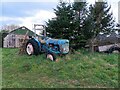
Old tractor
A rusty blue tractor on the edge of a field.
Image: © Pebble
Taken: 18 Mar 2023
0.16 miles
5
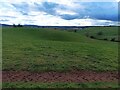
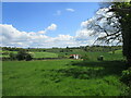
Rolling hills
A field with grassy rolling hills.
Image: © Pebble
Taken: 18 Mar 2023
0.24 miles
6
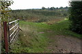
Orchards near Hill View Farm, Castle Tump
Image: © Philip Halling
Taken: 22 Oct 2005
0.24 miles