IMAGES TAKEN NEAR TO
Cliffords Mesne, NEWENT, GL18 1JR
Introduction
This page details the photographs taken nearby to GL18 1JR by members of the Geograph project.
The Geograph project started in 2005 with the aim of publishing, organising and preserving representative images for every square kilometre of Great Britain, Ireland and the Isle of Man.

There are currently over 7.5m images from over14,400 individuals and you can help contribute to the project by visiting https://www.geograph.org.uk
Image Map
Images are licensed for reuse under creativecommons.org/licenses/by-sa/2.0
Notes
- Clicking on the map will re-center to the selected point.
- The higher the marker number, the further away the image location is from the centre of the postcode.
Image Listing (20 Images Found)
Images are licensed for reuse under creativecommons.org/licenses/by-sa/2.0
Image
Details
Distance
1
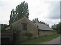
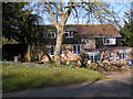
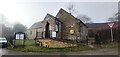
Barn at Springfield Grange, Clifford's Mesne
Image: © Jonathan Thacker
Taken: 26 Jul 2013
0.02 miles
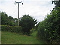
2
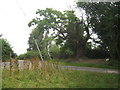
Restricted Byway - to Heaven?
Either the post has been hit by a vehicle or it was not very well installed.
Image: © Jonathan Thacker
Taken: 26 Jul 2013
0.08 miles
4
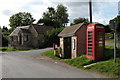
Bus stop and telephone box in the village of Clifford's Mesne
Image: © Philip Halling
Taken: 9 Oct 2005
0.11 miles
5
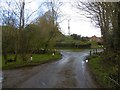
Road junction, Clifford's Mesne
Left for Oaks Lane, Aston Ingham and Herefordshire.
Image: © Richard Webb
Taken: 16 Apr 2016
0.12 miles
6
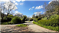
Grass triangle in Clifford's Mesne
Oak Lane to Aston Ingham to the right.
Image: © Jonathan Billinger
Taken: 15 Apr 2021
0.12 miles
7
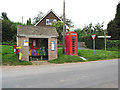
Postbox, Bus stop and Phone Box at a Road Junction
Good job there are a couple of parking spaces nearby.
Clifford's Mesne.
Image: © Pauline E
Taken: 8 Sep 2007
0.12 miles
10
Footpath at Clifford's Mesne
Part of a dense network of paths in this area.
Image: © Jonathan Thacker
Taken: 26 Jul 2013
0.15 miles