IMAGES TAKEN NEAR TO
Anthonys Cross, NEWENT, GL18 1JG
Introduction
This page details the photographs taken nearby to Anthonys Cross, GL18 1JG by members of the Geograph project.
The Geograph project started in 2005 with the aim of publishing, organising and preserving representative images for every square kilometre of Great Britain, Ireland and the Isle of Man.

There are currently over 7.5m images from over14,400 individuals and you can help contribute to the project by visiting https://www.geograph.org.uk
Image Map
Images are licensed for reuse under creativecommons.org/licenses/by-sa/2.0
Notes
- Clicking on the map will re-center to the selected point.
- The higher the marker number, the further away the image location is from the centre of the postcode.
Image Listing (4 Images Found)
Images are licensed for reuse under creativecommons.org/licenses/by-sa/2.0
Image
Details
Distance
1

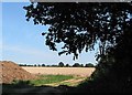
Field of stubble near Anthony's Cross
Tall woody stems of oilseed rape, waiting to be removed.
Image: © Pauline E
Taken: 23 Aug 2007
0.21 miles
3
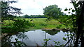
Pond at Moat Lodge
Plus a glimpse of The Moat in the next square north.
Image: © Jonathan Billinger
Taken: 30 Jun 2016
0.25 miles
4
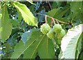
Horse chestnut fruits
Ripening in the August sun near the footpath.
Image: © Pauline E
Taken: 23 Aug 2007
0.25 miles