IMAGES TAKEN NEAR TO
Anthonys Cross, NEWENT, GL18 1JF
Introduction
This page details the photographs taken nearby to Anthonys Cross, GL18 1JF by members of the Geograph project.
The Geograph project started in 2005 with the aim of publishing, organising and preserving representative images for every square kilometre of Great Britain, Ireland and the Isle of Man.

There are currently over 7.5m images from over14,400 individuals and you can help contribute to the project by visiting https://www.geograph.org.uk
Image Map
Images are licensed for reuse under creativecommons.org/licenses/by-sa/2.0
Notes
- Clicking on the map will re-center to the selected point.
- The higher the marker number, the further away the image location is from the centre of the postcode.
Image Listing (8 Images Found)
Images are licensed for reuse under creativecommons.org/licenses/by-sa/2.0
Image
Details
Distance
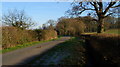
1
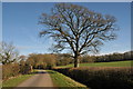
Road from Anthony's Cross
Road from Anthony's Cross to Kent's Green, Norman's Wood is on the right.
Image: © Philip Halling
Taken: 13 Mar 2011
0.03 miles
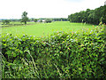
2
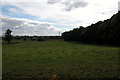
Norman's Wood
Norman's Wood is on the right, in the middle distance is Norman's Farm
Image: © Philip Halling
Taken: 9 Oct 2005
0.06 miles
3
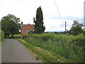
Country road between Anthony's Cross and Kent's Green
A single track road through farmland with few passing places.
Image: © Pauline E
Taken: 6 Jun 2008
0.09 miles
4
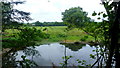
Pond at Moat Lodge
Plus a glimpse of The Moat in the next square north.
Image: © Jonathan Billinger
Taken: 30 Jun 2016
0.12 miles
5
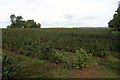
Field of currant bushes at Battle Ridge
This field is near Newent, in the distance are the Malvern Hills.
Image: © Philip Halling
Taken: 9 Oct 2005
0.14 miles
6
Woodland edge near Anthony's Cross
Looking south towards Normans. Power lines pass through the square.
Image: © Pauline E
Taken: 6 Jun 2008
0.14 miles
7
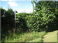
The beginning of the footpath at Battle Ridge
Image: © Jonathan Thacker
Taken: 30 Jun 2011
0.21 miles
8
From May Hill to Taynton -5
Looking toward Norman's wood. Is the reference to Battle Ridge nearby a clue to who Norman was?
Image: © David Robinson
Taken: 7 Dec 2008
0.24 miles