IMAGES TAKEN NEAR TO
Upleadon, NEWENT, GL18 1HL
Introduction
This page details the photographs taken nearby to GL18 1HL by members of the Geograph project.
The Geograph project started in 2005 with the aim of publishing, organising and preserving representative images for every square kilometre of Great Britain, Ireland and the Isle of Man.

There are currently over 7.5m images from over14,400 individuals and you can help contribute to the project by visiting https://www.geograph.org.uk
Image Map
Images are licensed for reuse under creativecommons.org/licenses/by-sa/2.0
Notes
- Clicking on the map will re-center to the selected point.
- The higher the marker number, the further away the image location is from the centre of the postcode.
Image Listing (7 Images Found)
Images are licensed for reuse under creativecommons.org/licenses/by-sa/2.0
Image
Details
Distance
2
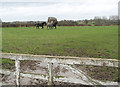
Paddock near Limbury Hill
There are four horses in the picture, three of them are trotting around the large paddock and a fourth can only watch over the hedge - Billy No-mates.
Image: © Pauline E
Taken: 30 Nov 2007
0.08 miles
3
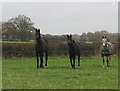
And they're off!
All three horses stood stock still with ears pricked as I raised the camera and as soon as I clicked the shutter they ran off - they've obviously done this before. I didn't notice the wire behind them until I downloaded the image - it looks as if they've just been under starter's orders.
Image: © Pauline E
Taken: 30 Nov 2007
0.08 miles
4
Lower House
Lower House is on the lane from Highleadon to Upleadon.
Image: © Philip Halling
Taken: 3 Sep 2005
0.13 miles
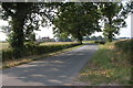
5
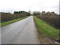
Lone cyclist heading for Upleadon
What a great road for cyclists - flat with little traffic and good visibility.
Image: © Pauline E
Taken: 30 Nov 2007
0.13 miles
6
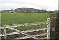
Paddock near Limbury Hill
Limbury Hill is covered with mixed woodland.
Image: © Pauline E
Taken: 30 Nov 2007
0.13 miles
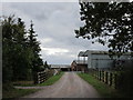
7
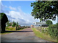
Upper House Farm
A sunny morning by the Gloucester Road, Upleadon.
Image: © Jonathan Billinger
Taken: 16 Jul 2010
0.15 miles