IMAGES TAKEN NEAR TO
Highleadon, NEWENT, GL18 1HH
Introduction
This page details the photographs taken nearby to GL18 1HH by members of the Geograph project.
The Geograph project started in 2005 with the aim of publishing, organising and preserving representative images for every square kilometre of Great Britain, Ireland and the Isle of Man.

There are currently over 7.5m images from over14,400 individuals and you can help contribute to the project by visiting https://www.geograph.org.uk
Image Map
Images are licensed for reuse under creativecommons.org/licenses/by-sa/2.0
Notes
- Clicking on the map will re-center to the selected point.
- The higher the marker number, the further away the image location is from the centre of the postcode.
Image Listing (7 Images Found)
Images are licensed for reuse under creativecommons.org/licenses/by-sa/2.0
Image
Details
Distance
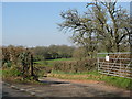
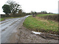
2
Park Road joins the road to Upleadon
At Highleadon Green.
Image: © Julian P Guffogg
Taken: 7 Aug 2013
0.10 miles
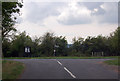
4
Upleadon Road by Green Farm Nurseries
Looking north; the wide verge to the left is common land.
Image: © Jonathan Billinger
Taken: 9 Aug 2010
0.14 miles
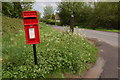
5
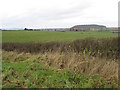
Grazing land at Highleadon
With Limbury Hill, and in the distance, the Malverns.
Image: © Pauline E
Taken: 30 Nov 2007
0.19 miles
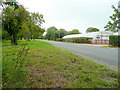
7
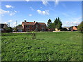
Cottages by the Green at Highleadon
Image: © Jonathan Thacker
Taken: 13 Sep 2018
0.24 miles