IMAGES TAKEN NEAR TO
Hooks Lane, NEWENT, GL18 1EL
Introduction
This page details the photographs taken nearby to Hooks Lane, GL18 1EL by members of the Geograph project.
The Geograph project started in 2005 with the aim of publishing, organising and preserving representative images for every square kilometre of Great Britain, Ireland and the Isle of Man.

There are currently over 7.5m images from over14,400 individuals and you can help contribute to the project by visiting https://www.geograph.org.uk
Image Map
Images are licensed for reuse under creativecommons.org/licenses/by-sa/2.0
Notes
- Clicking on the map will re-center to the selected point.
- The higher the marker number, the further away the image location is from the centre of the postcode.
Image Listing (3 Images Found)
Images are licensed for reuse under creativecommons.org/licenses/by-sa/2.0
Image
Details
Distance
1
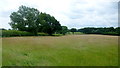
View to Grinnell's Wood
Grassland and woods to the south of Upleadon.
Image: © Jonathan Billinger
Taken: 30 Jun 2016
0.10 miles
2
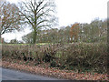
Deciduous woodland, Upleadon
Unnamed on the map.
Image: © Pauline E
Taken: 30 Nov 2007
0.17 miles
3
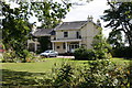
Upleadon Village, Detached dwelling
Detached dwelling on the outskirts of Upleadon village, Gloucestershire.
Image: © Colin Manton
Taken: 14 Jun 2011
0.25 miles