IMAGES TAKEN NEAR TO
Forge Lane, NEWENT, GL18 1EG
Introduction
This page details the photographs taken nearby to Forge Lane, GL18 1EG by members of the Geograph project.
The Geograph project started in 2005 with the aim of publishing, organising and preserving representative images for every square kilometre of Great Britain, Ireland and the Isle of Man.

There are currently over 7.5m images from over14,400 individuals and you can help contribute to the project by visiting https://www.geograph.org.uk
Image Map
Images are licensed for reuse under creativecommons.org/licenses/by-sa/2.0
Notes
- Clicking on the map will re-center to the selected point.
- The higher the marker number, the further away the image location is from the centre of the postcode.
Image Listing (4 Images Found)
Images are licensed for reuse under creativecommons.org/licenses/by-sa/2.0
Image
Details
Distance
1
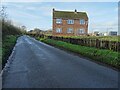
House on Forge Lane
A house on Forge Lane in Upleadon; it appears to date from the 1960s and looks like it is about to be redeveloped.
Image: © Philip Halling
Taken: 5 Dec 2020
0.00 miles
2
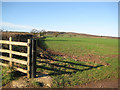
Field edge near Upleadon Court
To Eden's Hill and Collinpark Wood.
Image: © Pauline E
Taken: 6 Feb 2008
0.06 miles
3
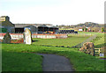
Looking west from Upleadon Court
From the churchyard you can see farm buildings and the village of Upleadon on the rise beyond with Collinpark Wood on the horizon.
Image: © Pauline E
Taken: 6 Feb 2008
0.12 miles
4
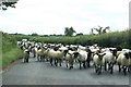
Sheep in the road
An unexpected encounter on the road near Upleadon
Image: © Richard Croft
Taken: 12 Jun 2009
0.15 miles