IMAGES TAKEN NEAR TO
Upleadon, NEWENT, GL18 1ED
Introduction
This page details the photographs taken nearby to GL18 1ED by members of the Geograph project.
The Geograph project started in 2005 with the aim of publishing, organising and preserving representative images for every square kilometre of Great Britain, Ireland and the Isle of Man.

There are currently over 7.5m images from over14,400 individuals and you can help contribute to the project by visiting https://www.geograph.org.uk
Image Map
Images are licensed for reuse under creativecommons.org/licenses/by-sa/2.0
Notes
- Clicking on the map will re-center to the selected point.
- The higher the marker number, the further away the image location is from the centre of the postcode.
Image Listing (4 Images Found)
Images are licensed for reuse under creativecommons.org/licenses/by-sa/2.0
Image
Details
Distance
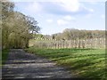
2
Edge of the orchard
Near Carswalls Manor.
Lots of clumps of mistletoe visible at this time of year. Buzzards were hunting in the open space.
Image: © Pauline E
Taken: 30 Nov 2007
0.20 miles
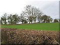
3
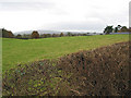
Grazing land between Newent and Upleadon
With May Hill in the distance.
Image: © Pauline E
Taken: 30 Nov 2007
0.23 miles
4
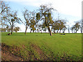
Orchard near Carswalls Manor
A feature of much of the square. Mistletoe invasion much in evidence during the winter.
Image: © Pauline E
Taken: 6 Feb 2008
0.23 miles