IMAGES TAKEN NEAR TO
Botloes Green, NEWENT, GL18 1DW
Introduction
This page details the photographs taken nearby to Botloes Green, GL18 1DW by members of the Geograph project.
The Geograph project started in 2005 with the aim of publishing, organising and preserving representative images for every square kilometre of Great Britain, Ireland and the Isle of Man.

There are currently over 7.5m images from over14,400 individuals and you can help contribute to the project by visiting https://www.geograph.org.uk
Image Map
Images are licensed for reuse under creativecommons.org/licenses/by-sa/2.0
Notes
- Clicking on the map will re-center to the selected point.
- The higher the marker number, the further away the image location is from the centre of the postcode.
Image Listing (6 Images Found)
Images are licensed for reuse under creativecommons.org/licenses/by-sa/2.0
Image
Details
Distance
2
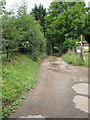
Footpath north from Botloe's Green
Heading for Cottage Farm.
Image: © Pauline E
Taken: 7 Aug 2008
0.08 miles
3
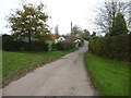
Minor road south from Botloe's Green
To The Scarr.
Image: © Pauline E
Taken: 7 Aug 2008
0.11 miles
4
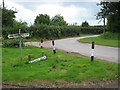
Botloe's Green
Road junction and small green at Botloe's Green.
Image: © Philip Halling
Taken: 22 Oct 2005
0.12 miles
5
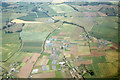
Aerial view - market gardening at Botloe's Green near Newent
The centre of the photograph is looking east along Scarr Road.
Image: © Colin Park
Taken: 16 Jul 1978
0.22 miles
6
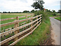
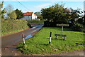
Single track road to Pauntley
The pipeline marker and new fence mark this as part of the recent Felindre to Tirley installation.
Image: © Pauline E
Taken: 7 Aug 2008
0.25 miles