IMAGES TAKEN NEAR TO
Three Ashes Lane, NEWENT, GL18 1DG
Introduction
This page details the photographs taken nearby to Three Ashes Lane, GL18 1DG by members of the Geograph project.
The Geograph project started in 2005 with the aim of publishing, organising and preserving representative images for every square kilometre of Great Britain, Ireland and the Isle of Man.

There are currently over 7.5m images from over14,400 individuals and you can help contribute to the project by visiting https://www.geograph.org.uk
Image Map
Images are licensed for reuse under creativecommons.org/licenses/by-sa/2.0
Notes
- Clicking on the map will re-center to the selected point.
- The higher the marker number, the further away the image location is from the centre of the postcode.
Image Listing (7 Images Found)
Images are licensed for reuse under creativecommons.org/licenses/by-sa/2.0
Image
Details
Distance
1
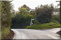
Junction on Redmarley road
Pool Hill and Ketford to the right via The Scarr.
Image: © J.Hannan-Briggs
Taken: 13 Oct 2016
0.01 miles
2
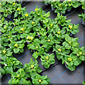
Commercial crop of primroses
Seed-raised plants at Trioscape's wholesale nursery.
Image: © Jonathan Billinger
Taken: 10 Jan 2022
0.09 miles
3

Derelict glasshouses
The area to the north of Newent is a patchwork of horticultural businesses, some now defunct.
Image: © Jonathan Billinger
Taken: 9 Jul 2024
0.14 miles
4
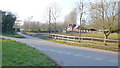
The Scarr
Centre of a network of minor roads north of Newent.
Image: © Jonathan Billinger
Taken: 11 Mar 2014
0.18 miles
5
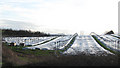
A square of glass and polythene
Not much happening here in February but one thing that did strike me was the size of the lorries using this minor road.
Image: © Pauline E
Taken: 6 Feb 2008
0.20 miles
6
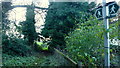
Footpath from Three Ashes Lane
The stile that I photographed in Image back in 2009 can be seen past the ivy-clad trees.
Image: © Jonathan Billinger
Taken: 27 Nov 2015
0.23 miles
7
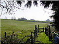
Footpath off Three Ashes Lane
The path heads south-east across pastoral land.
Image: © Jonathan Billinger
Taken: 6 Mar 2009
0.24 miles