IMAGES TAKEN NEAR TO
Walkers Lane, RUARDEAN, GL17 9XN
Introduction
This page details the photographs taken nearby to Walkers Lane, GL17 9XN by members of the Geograph project.
The Geograph project started in 2005 with the aim of publishing, organising and preserving representative images for every square kilometre of Great Britain, Ireland and the Isle of Man.

There are currently over 7.5m images from over14,400 individuals and you can help contribute to the project by visiting https://www.geograph.org.uk
Image Map (Loading...)


Getting Data...Please wait
Leaflet Map data © OpenStreetMap
Images are licensed for reuse under creativecommons.org/licenses/by-sa/2.0
Notes
- Clicking on the map will re-center to the selected point.
- The higher the marker number, the further away the image location is from the centre of the postcode.
Image Listing (14 Images Found)
Images are licensed for reuse under creativecommons.org/licenses/by-sa/2.0
Image
Details
Distance
1
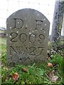
Boundary Stone, Ruardean Woodside
Royal Forest of Dean boundary stone on the West side of Walker's Lane opposite the farmyard entrance. It also marks the boundary between Ruardean and East Dean, Gloucestershire.
Inscription: D. F. / 2009 / Nᴼ. 127
Milestone Society National ID: GL_DFDRRU127em
Image: © Mr Red
Taken: 4 Feb 2023
0.07 miles
2

Boundary Stone, Ruardean Woodside
Forest of Dean boundary stone on the West side of Walker's Lane and adjacent to Gloucestershire footpath DRD45.
Inscription: D. F. / 2015 / Nᴼ. 126
Milestone Society National ID: GL_DFDRRU126em
Image: © Mr Red
Taken: 4 Feb 2023
0.10 miles
3
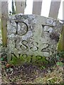
Boundary Stone, Ruardean Hill
Forest of Dean boundary stone at the corner of Spout Lane and a stile on Gloucestershire footpath DRD41.
Inscription: D. F. / 1832 / Nᴼ. 128
Milestone Society National ID: GL_DFDRRU128em
Image: © Mr Red
Taken: 4 Feb 2023
0.10 miles
4
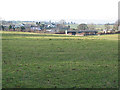
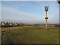
Grazing land northeast of Ruardean Woodside
Image: © Pauline E
Taken: 12 Dec 2007
0.11 miles
5
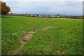
View to the west from Ruardean Hill
At 290m Ruardean Hill provides a good viewpoint.
Image: © Philip Halling
Taken: 3 Nov 2012
0.18 miles
6
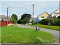
Duttons Lane, Ruardean Woodside
At the junction with Forest Road.
Image: © Jonathan Billinger
Taken: 30 Jul 2009
0.22 miles
7
Toposcope on Ruardean Hill
A winters sun sets behind the Toposcope on Ruardean Hill at Pan Tod Beacon.
Image: © Stuart Wilding
Taken: 11 Jan 2014
0.22 miles
8
Toposcope on Ruardean Hill
A nearby plaque (though it may be on the toposcope itself) declares this to be the highest point in the Forest of Dean. However the beacon behind looks to be higher and a flagpole in the distance, though difficult to make out, appears to be even higher still.
Image: © Stuart Wilding
Taken: 11 Jan 2014
0.23 miles
9
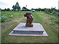
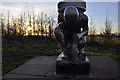
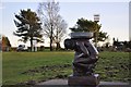
Miner's Statue At Pan Tod Beacon
Gate shut so access to trig and covered reservoir via hole in fence. Much better views from beacon near new statue.
Name: Ruardean Hill
Hill number: 2862
Height: 290m / 951ft
Area: 38B: West Gloucestershire, Hereford & Worcester
Class: Ma
Grid ref: SO 63494 16919
Summit feature: site of original flagpole
Drop: 174m
Col: 116m SO681214
Image: © Rude Health
Taken: 4 Jun 2008
0.23 miles
10
Ruardean Hill Beacon, Pan-Tod
With walling repairs in progress beyond the fence on the left.
Image: © Pauline E
Taken: 12 Dec 2007
0.24 miles