IMAGES TAKEN NEAR TO
Eddys Lane, RUARDEAN, GL17 9TS
Introduction
This page details the photographs taken nearby to Eddys Lane, GL17 9TS by members of the Geograph project.
The Geograph project started in 2005 with the aim of publishing, organising and preserving representative images for every square kilometre of Great Britain, Ireland and the Isle of Man.

There are currently over 7.5m images from over14,400 individuals and you can help contribute to the project by visiting https://www.geograph.org.uk
Image Map (Loading...)


Getting Data...Please wait
Leaflet Map data © OpenStreetMap
Images are licensed for reuse under creativecommons.org/licenses/by-sa/2.0
Notes
- Clicking on the map will re-center to the selected point.
- The higher the marker number, the further away the image location is from the centre of the postcode.
Image Listing (19 Images Found)
Images are licensed for reuse under creativecommons.org/licenses/by-sa/2.0
Image
Details
Distance
1
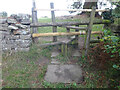
Stone Stile, Ruardean
On Gloucestershire footpath DRD32 off Eddys Lane. The remnants of a "Fallen Idle".
Image: © Mr Red
Taken: 27 Sep 2022
0.03 miles
2
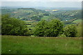
The Wye valley viewed from near Joy's Green
From the high ground to the west of Ruardean there are superb views across the Wye valley and Herefordshire to the Welsh borders. The River Wye can be seen in the valley downstream from Kerne Bridge.
Image: © Philip Halling
Taken: 10 May 2009
0.04 miles
3
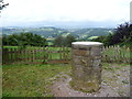
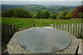
Toposcope near Ruardean
On a clearer day I expect it is possible to get sharper views.
Image: © Jeremy Bolwell
Taken: 5 Aug 2012
0.04 miles
4
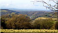
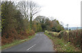
View to the Wye valley, and beyond
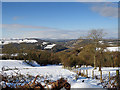
Eddy's Lane crosses one of the highest points in the Forest of Dean, and the view from this spot is wide ranging.
Image: © Jonathan Billinger
Taken: 16 Feb 2018
0.05 miles
5
Toposcope near Joy's Green
Toposcope above the Wye valley near Joy's Green, from here there are superb views across the Wye valley and south Herefordshire.
Image: © Philip Halling
Taken: 10 May 2009
0.05 miles
6
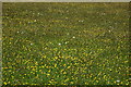
A field of spring flowers
A traditional grazing field which appears never to have receive a spray of agro-chemicals.
Image: © Philip Halling
Taken: 10 May 2009
0.07 miles
9
View from near Joys Green
Looking over the Wye Valley towards the distant Black Mountains.
Image: © Stuart Wilding
Taken: 10 Feb 2009
0.12 miles
10
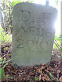
Modern Boundary Stone, Ruardean
High on the Northern embankment of "Townsend". One of the many replacement boundary stone delineating the periphery of the "Forest of Dean". The "Forest" is very specific because resident have "rights in common" like grazing sheep and coal mining, though you may have to be born there to classify as a "free miner".
Inscription: D. F. / No 116 / 2010
Milestone Society National ID: GL_DFRUAR116em
Image: © Mr Red
Taken: 27 Sep 2022
0.13 miles