IMAGES TAKEN NEAR TO
Church Road, LYDBROOK, GL17 9SH
Introduction
This page details the photographs taken nearby to Church Road, GL17 9SH by members of the Geograph project.
The Geograph project started in 2005 with the aim of publishing, organising and preserving representative images for every square kilometre of Great Britain, Ireland and the Isle of Man.

There are currently over 7.5m images from over14,400 individuals and you can help contribute to the project by visiting https://www.geograph.org.uk
Image Map (Loading...)


Getting Data...Please wait
Leaflet Map data © OpenStreetMap
Images are licensed for reuse under creativecommons.org/licenses/by-sa/2.0
Notes
- Clicking on the map will re-center to the selected point.
- The higher the marker number, the further away the image location is from the centre of the postcode.
Image Listing (101 Images Found)
Images are licensed for reuse under creativecommons.org/licenses/by-sa/2.0
Image
Details
Distance
1
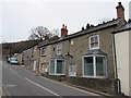
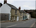
Old Crown & Sceptre, Upper Lydbrook
Viewed across Church Road in March 2016. The house with the bay windows used to be the Crown & Sceptre pub. The inscription on the small tablet on the wall above the lamp is WCM 1814 JM 1848.
Image: © Jaggery
Taken: 20 Mar 2016
0.00 miles
2
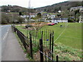
Kissing gate access to a football pitch, Lydbrook
From Church Road.
Image: © Jaggery
Taken: 20 Mar 2016
0.01 miles
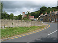
4
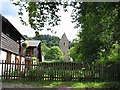
Down Church Hill, Lydbrook
Looking south down Church Hill in March 2016. The Parish Church of the Holy Jesus https://www.geograph.org.uk/photo/4956830 is near the camera.
Image: © Jaggery
Taken: 20 Mar 2016
0.02 miles
5
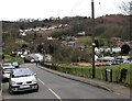
Stone houses, Church Road, Lydbrook
Alongside the descent towards the B4234 junction.
Image: © Jaggery
Taken: 20 Mar 2016
0.02 miles
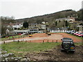
7
Excavator and road roller in Upper Lydbrook
Set back from the southern end of Church Road above the B4234 junction, viewed in March 2016.
Image: © Jaggery
Taken: 20 Mar 2016
0.03 miles
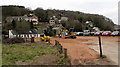
8
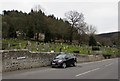
Development site in Lydbrook
Looking from Church Road towards a bulldozer and a road roller in March 2016.
A September 2009 Google Street View shows a car park here.
Image: © Jaggery
Taken: 20 Mar 2016
0.03 miles
9
Lydbrook churchyard above Church Road
On the south side of the Parish Church of the Holy Jesus. http://www.geograph.org.uk/photo/4956861
Image: © Jaggery
Taken: 20 Mar 2016
0.03 miles
10
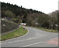
Junction of Church Road and the B4234 in Lydbrook
Viewed across the B4234.
Image: © Jaggery
Taken: 20 Mar 2016
0.04 miles