IMAGES TAKEN NEAR TO
The Branch, LYDBROOK, GL17 9SD
Introduction
This page details the photographs taken nearby to The Branch, GL17 9SD by members of the Geograph project.
The Geograph project started in 2005 with the aim of publishing, organising and preserving representative images for every square kilometre of Great Britain, Ireland and the Isle of Man.

There are currently over 7.5m images from over14,400 individuals and you can help contribute to the project by visiting https://www.geograph.org.uk
Image Map
Images are licensed for reuse under creativecommons.org/licenses/by-sa/2.0
Notes
- Clicking on the map will re-center to the selected point.
- The higher the marker number, the further away the image location is from the centre of the postcode.
Image Listing (55 Images Found)
Images are licensed for reuse under creativecommons.org/licenses/by-sa/2.0
Image
Details
Distance
1
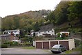
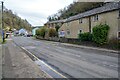
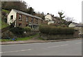
Lydbrook
Houses on steep slopes on the edge of the Forest of Dean.
Image: © Richard Webb
Taken: 19 Oct 2015
0.02 miles
2
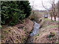
Lyd Brook, Central Lydbrook
The brook here is about a kilometre from the River Wye, into which it flows in Lower Lydbrook.
Lyd Brook is also known as Hough Brook or Great Hough Brook.
Image: © Jaggery
Taken: 20 Mar 2016
0.04 miles
3
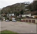
Hillside view from Central Lydbrook
Located in a hilly part of the Forest of Dean in west Gloucestershire, Central Lydbrook is part of the civil parish of Lydbrook, which also includes Lower Lydbrook, Upper Lydbrook, Joys Green and Worrall Hill.
Image: © Jaggery
Taken: 20 Mar 2016
0.04 miles
4
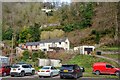
Lydbook : Car Park
A car park alongside the social club in Lower Lydbrook.
Image: © Lewis Clarke
Taken: 22 Mar 2023
0.04 miles
5
Lydbrook : B4234
Looking along the road.
Image: © Lewis Clarke
Taken: 22 Mar 2023
0.05 miles
6
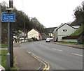
Weight limit sign in Central Lydbrook
Facing the B4234 on the approach to the New Road Hangerberry junction.
Image: © Jaggery
Taken: 20 Mar 2016
0.05 miles
7
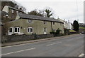
Gravel Cottage, Central Lydbrook
Viewed across the B4234, the main road through the village.
Image: © Jaggery
Taken: 20 Mar 2016
0.05 miles
8
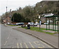
Bus stop and shelter in Central Lydbrook
Alongside the B4234, the main road through the village. This side for southbound buses.
Image: © Jaggery
Taken: 20 Mar 2016
0.06 miles
9
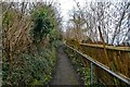
Lydbrook : Bell Hill
Looking along a footpath up the hillside.
Image: © Lewis Clarke
Taken: 22 Mar 2023
0.06 miles
10
Junction of Bell Hill and the B4234, Central Lydbrook
The B4234 is the main road through the village. Bell Hill is the narrow lane on the left.
The Bell Hill name sign shows NO THROUGH ROAD.
Image: © Jaggery
Taken: 20 Mar 2016
0.06 miles