IMAGES TAKEN NEAR TO
Rocks Road, LYDBROOK, GL17 9RQ
Introduction
This page details the photographs taken nearby to Rocks Road, GL17 9RQ by members of the Geograph project.
The Geograph project started in 2005 with the aim of publishing, organising and preserving representative images for every square kilometre of Great Britain, Ireland and the Isle of Man.

There are currently over 7.5m images from over14,400 individuals and you can help contribute to the project by visiting https://www.geograph.org.uk
Image Map (Loading...)


Getting Data...Please wait
Leaflet Map data © OpenStreetMap
Images are licensed for reuse under creativecommons.org/licenses/by-sa/2.0
Notes
- Clicking on the map will re-center to the selected point.
- The higher the marker number, the further away the image location is from the centre of the postcode.
Image Listing (11 Images Found)
Images are licensed for reuse under creativecommons.org/licenses/by-sa/2.0
Image
Details
Distance
3
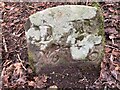
Dean Forest Boundary Stone, Lydbrook
On Gloucestershire footpath RLY26 actually in Lower Lydbrook.
Inscription: D. F. / Nᴼ. 115 / 1832
Milestone Society National ID: GL_DFLYD115em
Image: © David Viner
Taken: 24 Feb 2023
0.16 miles
4
Joy's Green
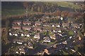
A typical Forest of Dean community set on a hillside high above the Wye Valley and Lydbrook.
Viewed from the same weedy field as Image
Image: © Jonathan Billinger
Taken: 3 Aug 2009
0.16 miles
5
Lydbrook
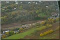
Site of demolished factory.
Image: © Peter Randall-Cook
Taken: 7 Nov 2010
0.22 miles
6

Small footpath near Lydbrook
This footpath runs by the River Wye for a short distance.
Image: © Stuart Wilding
Taken: 8 Oct 2008
0.23 miles
7
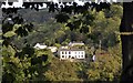
View across the Valley
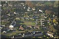
View across the valley in Lower Lydbrook. The house is on Forge Hill.
Image: © Stuart Wilding
Taken: 16 Oct 2013
0.23 miles
8
Entering Joy's Green from Ruardean
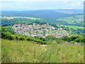
A hillside village enjoying stunning views.
Image: © Pauline E
Taken: 14 Nov 2007
0.23 miles
9
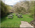
Royal Spring Inn picnic tables, Lower Lydbrook
On the west side of the inn http://www.geograph.org.uk/photo/4902543 separated from it by Vention Lane.
Image: © Jaggery
Taken: 10 Apr 2016
0.24 miles
10
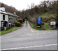
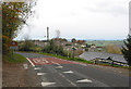
Vention Lane, Lower Lydbrook
At the edge of Lower Lydbrook, Vention Lane climbs away from the B4234 on the south bank of the River Wye. Blue signs show Single track road - no passing places for 1 mile and Unsuitable for heavy goods vehicles.
The gradient gets steeper ahead.
Image: © Jaggery
Taken: 10 Apr 2016
0.25 miles