IMAGES TAKEN NEAR TO
Central Lydbrook, LYDBROOK, GL17 9PP
Introduction
This page details the photographs taken nearby to GL17 9PP by members of the Geograph project.
The Geograph project started in 2005 with the aim of publishing, organising and preserving representative images for every square kilometre of Great Britain, Ireland and the Isle of Man.

There are currently over 7.5m images from over14,400 individuals and you can help contribute to the project by visiting https://www.geograph.org.uk
Image Map (Loading...)


Getting Data...Please wait
Leaflet Map data © OpenStreetMap
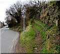
Images are licensed for reuse under creativecommons.org/licenses/by-sa/2.0
Notes
- Clicking on the map will re-center to the selected point.
- The higher the marker number, the further away the image location is from the centre of the postcode.
Image Listing (119 Images Found)
Images are licensed for reuse under creativecommons.org/licenses/by-sa/2.0
Image
Details
Distance
1
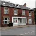
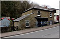
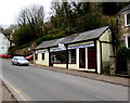
Central Lydbrook shopfront
Located opposite the New Road Hangerberry junction, http://www.geograph.org.uk/photo/4875379 the shopfront is on the east side of the B4234, the main road through the village. In March 2016 there are notices in the windows, but no name on the nameboard.
Image: © Jaggery
Taken: 20 Mar 2016
0.01 miles
2
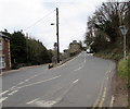
Distances and directions from Central Lydbrook
Facing the New Road Hangerberry junction, http://www.geograph.org.uk/photo/4875379 the signpost is alongside the B4234, the main road through the village. Left for Ross(-on-Wye) (7 miles). Right for Joys Green (half a mile) and Lydney (9 miles).
Image: © Jaggery
Taken: 20 Mar 2016
0.01 miles
3
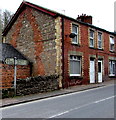
Upper Lydbrook
The buildings on the right show the steep hill through the village. In the terrace, the lowest building has a shop window, and several steps to the shop door. The highest building needs no steps to its door.
Image: © David Smith
Taken: 24 Jul 2013
0.02 miles
4
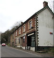
Orchard Trust main office, Central Lydbrook
Viewed across the B4234, the main road through the village. An independent registered charity based in the Forest of Dean, Orchard Trust provides a wide range of integrated services to meet the needs of people with learning disabilities in Gloucestershire and the surrounding area. Services include residential care, respite care, supported living, domiciliary care, education, staff training and day services.
Image: © Jaggery
Taken: 20 Mar 2016
0.02 miles
5
Volume unisex hair salon, Central Lydbrook
A March 2016 view across the B4234, the main road through the village.
The For Sale sign on the side wall is for the first floor flat.
A September 2009 Google Earth Street View shows the name Jenstyle here. The shop was for sale at that time.
Image: © Jaggery
Taken: 20 Mar 2016
0.02 miles
6
Junction in Central Lydbrook
New Road Hangberry on the right diverges from the B4234, the main road through the village.
Image: © Jaggery
Taken: 20 Mar 2016
0.02 miles
7
Midland Bank House, Central Lydbrook
Viewed across the B4234, the main road through the village. The detached house is opposite the Wye Fry. http://www.geograph.org.uk/photo/4875272
A small label stuck on a window shows MIDLAND BANK HOUSE. An online source states that this used to be a small Midland Bank branch which was open only one day a week. The branch closed down in the early 1990s.
I did not see any bank branches in Central Lydbrook today (March 20th 2016).
Image: © Jaggery
Taken: 20 Mar 2016
0.03 miles
8
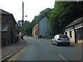
Lydbrook : B4234
Looking along the B4234.
Image: © Lewis Clarke
Taken: 22 Mar 2023
0.03 miles
9
Track ascending from New Road Hangberry in Central Lydbrook
At the right edge of this junction. http://www.geograph.org.uk/photo/4875379
Image: © Jaggery
Taken: 20 Mar 2016
0.03 miles
10
The Wye Fry, Central Lydbrook
Takeaway (fish & chips, burgers, pizzas etc) alongside the B4234, the main road through the village.
The name is a reference to the River Wye which is about a kilometre to the north, in Lower Lydbrook.
Image: © Jaggery
Taken: 20 Mar 2016
0.04 miles