IMAGES TAKEN NEAR TO
Lower Lydbrook, LYDBROOK, GL17 9NU
Introduction
This page details the photographs taken nearby to Lower Lydbrook, GL17 9NU by members of the Geograph project.
The Geograph project started in 2005 with the aim of publishing, organising and preserving representative images for every square kilometre of Great Britain, Ireland and the Isle of Man.

There are currently over 7.5m images from over14,400 individuals and you can help contribute to the project by visiting https://www.geograph.org.uk
Image Map (Loading...)


Getting Data...Please wait
Leaflet Map data © OpenStreetMap
Images are licensed for reuse under creativecommons.org/licenses/by-sa/2.0
Notes
- Clicking on the map will re-center to the selected point.
- The higher the marker number, the further away the image location is from the centre of the postcode.
Image Listing (52 Images Found)
Images are licensed for reuse under creativecommons.org/licenses/by-sa/2.0
Image
Details
Distance
1

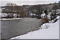
Small footpath near Lydbrook
This footpath runs by the River Wye for a short distance.
Image: © Stuart Wilding
Taken: 8 Oct 2008
0.04 miles

4
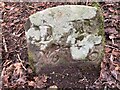
Dean Forest Boundary Stone, Lydbrook
On Gloucestershire footpath RLY26 actually in Lower Lydbrook.
Inscription: D. F. / Nᴼ. 115 / 1832
Milestone Society National ID: GL_DFLYD115em
Image: © David Viner
Taken: 24 Feb 2023
0.12 miles
5
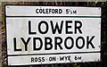
Lower Lydbrook boundary sign
On the right here, http://www.geograph.org.uk/photo/4902301 on the corner of Vention Lane and the B4234, 5½ miles from Coleford (Gloucestershire) and 6 miles from Ross-on-Wye (Herefordshire). Lower Lydbrook is part of Lydbrook civil parish in the Forest of Dean local government district of Gloucestershire.
Image: © Jaggery
Taken: 10 Apr 2016
0.13 miles
6
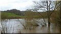
River Wye in flood
A lot of rain in Wales in the last two days...
Image: © Jonathan Billinger
Taken: 13 Mar 2019
0.13 miles
7
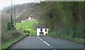
B4234 near Vention Lane junction
Road here leads out of Lower Lydbrook. River Wye to left and turning to right leads to the Royal Spring public house.
Image: © Clint Mann
Taken: 12 Apr 2004
0.13 miles
8

River Wye at Lower Lydbrook
Looking upstream.
Image: © Jonathan Billinger
Taken: 26 Jul 2023
0.13 miles
9
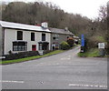
Vention Lane houses, Lower Lydbrook
Viewed across the junction of the B4234 and Vention Lane.
The Lower Lydbrook boundary sign http://www.geograph.org.uk/photo/4902312 is on the right.
Image: © Jaggery
Taken: 10 Apr 2016
0.13 miles
10
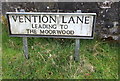
Vention Lane name sign, Lower Lydbrook
Located on the left here. http://www.geograph.org.uk/photo/4902479 The British History website states that Vention Lane
"apparently took its name from a coal mine known in the later 17th century as New Invention"
Image: © Jaggery
Taken: 10 Apr 2016
0.14 miles