IMAGES TAKEN NEAR TO
Forge Row, LYDBROOK, GL17 9NP
Introduction
This page details the photographs taken nearby to Forge Row, GL17 9NP by members of the Geograph project.
The Geograph project started in 2005 with the aim of publishing, organising and preserving representative images for every square kilometre of Great Britain, Ireland and the Isle of Man.

There are currently over 7.5m images from over14,400 individuals and you can help contribute to the project by visiting https://www.geograph.org.uk
Image Map
Images are licensed for reuse under creativecommons.org/licenses/by-sa/2.0
Notes
- Clicking on the map will re-center to the selected point.
- The higher the marker number, the further away the image location is from the centre of the postcode.
Image Listing (103 Images Found)
Images are licensed for reuse under creativecommons.org/licenses/by-sa/2.0
Image
Details
Distance
1
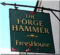
Forge Hammer pub name sign, Lower Lydbrook
Hanging from a wall bracket here. http://www.geograph.org.uk/photo/4903917
Image: © Jaggery
Taken: 10 Apr 2016
0.00 miles
2
Lydbrook : The Forge Hammer and River Spice Indian
The Forge Hammer & River Spice, Indian restaurant in Lydbrook.
Image: © Lewis Clarke
Taken: 22 Mar 2023
0.01 miles
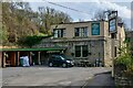
3
Forge Hammer and River Spice, Lower Lydbrook
River Spice Indian cuisine restaurant & takeaway is inside the Forge Hammer pub in Forge Row.
Image: © Jaggery
Taken: 10 Apr 2016
0.01 miles
4
Bend on B4234 approaching junction at River Wye
This part of Lower Lydbrook is prone to flooding from the River Wye
Image: © Clint Mann
Taken: Unknown
0.02 miles
5
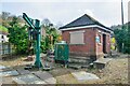
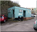
Lydbrook : Sewage Pumping Station
A sewage pumping station in Lydbrook.
Image: © Lewis Clarke
Taken: 22 Mar 2023
0.02 miles
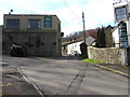
6
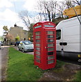
Red phonebox in Lower Lydbrook
On the corner of the B4234 and Forge Row.
Image: © Jaggery
Taken: 10 Apr 2016
0.02 miles
7
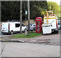
Red phonebox between two white vans, Lower Lydbrook
The highway maintenance van on the right is fitted with a Versalift,
an access platform which can be extended for working on street lamps etc.
Image: © Jaggery
Taken: 10 Apr 2016
0.02 miles
8
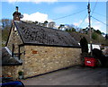
Old Forge Cottage, Lower Lydbrook
One of several former industrial buildings in a side road on the east side of the B4234.
Image: © Jaggery
Taken: 10 Apr 2016
0.02 miles
9
Lower Lydbrook public toilets
Open on a Sunday, clean and with full facilities - well done, Lower Lydbrook!
Image: © Jaggery
Taken: 10 Apr 2016
0.02 miles
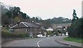
10
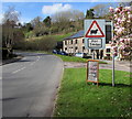
Warning sign - sheep for 7 miles, Lower Lydbrook
The sign is alongside the B4234, facing the Stowfield Road junction.
Lower Lydbrook is part of the Forest of Dean local government district,
where sheep roam freely across the road in some locations. I didn't see any examples today.
Here's http://www.geograph.org.uk/photo/3447020 an example from High Street Bream taken in May 2013.
Image: © Jaggery
Taken: 10 Apr 2016
0.02 miles