IMAGES TAKEN NEAR TO
LYDBROOK, GL17 9NB
Introduction
This page details the photographs taken nearby to GL17 9NB by members of the Geograph project.
The Geograph project started in 2005 with the aim of publishing, organising and preserving representative images for every square kilometre of Great Britain, Ireland and the Isle of Man.

There are currently over 7.5m images from over14,400 individuals and you can help contribute to the project by visiting https://www.geograph.org.uk
Image Map (Loading...)


Getting Data...Please wait
Leaflet Map data © OpenStreetMap
Images are licensed for reuse under creativecommons.org/licenses/by-sa/2.0
Notes
- Clicking on the map will re-center to the selected point.
- The higher the marker number, the further away the image location is from the centre of the postcode.
Image Listing (97 Images Found)
Images are licensed for reuse under creativecommons.org/licenses/by-sa/2.0
Image
Details
Distance
1
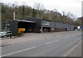
Lydwood, Lower Lydbrook
Viewed across the B4234. Lydwood was established in 1964 when Robert Jones set up in business to manufacture cedar wood home extensions.
In 2016, the business's website states that Lydwood manufactures components from a variety of predominantly wood-based materials using both traditional machinery and CNC technology. CNC (Computer Numerical Control) machines cut shapes quickly, efficiently and accurately with minimal waste.
Image: © Jaggery
Taken: 20 Mar 2016
0.01 miles
2
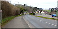
NNW along the B4234, Lower Lydbrook
Baptist Chapel Cottages http://www.geograph.org.uk/photo/4871025 are on the left. The south bank of the River Wye is about 500 metres ahead.
Image: © Jaggery
Taken: 20 Mar 2016
0.03 miles
3
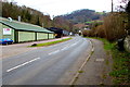
B4234 in Lower Lydbrook
Looking along the B4234 towards Central Lydbrook.
The green Central Engineering Works building http://www.geograph.org.uk/photo/4872348 is on the left.
The building behind it is the premises of Lydwood http://www.geograph.org.uk/photo/4872341 in March 2016.
Image: © Jaggery
Taken: 20 Mar 2016
0.03 miles
4
40mph speed limit sign, Lower Lydbrook
Alongside the B4234. The blue car is parked at the edge of the Central Engineering Works. http://www.geograph.org.uk/photo/4872348
Image: © Jaggery
Taken: 20 Mar 2016
0.04 miles
5
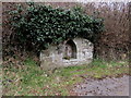
Former water fountain or trough, Lower Lydbrook
On the west side of the B4234, opposite the Central Engineering Works. http://www.geograph.org.uk/photo/4872348
Image: © Jaggery
Taken: 20 Mar 2016
0.04 miles
6
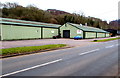
CBR, Lower Lydbrook
CBR (Car Body Repair) is located in the Central Engineering Works alongside the B4234.
Image: © Jaggery
Taken: 20 Mar 2016
0.06 miles
7
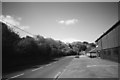
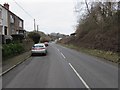
B4234 at Lower Lydbrook
Taken looking the other way from Image, and if anything, it's even duller!
Image: © John Winder
Taken: 9 May 2015
0.07 miles
8
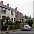
Baptist Chapel Cottages, Lower Lydbrook
Viewed across the B4234. The short row of houses is immediately north of Lydbrook Baptist Church. http://www.geograph.org.uk/photo/4871011
Image: © Jaggery
Taken: 20 Mar 2016
0.07 miles
9
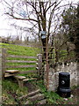
Roadside litter bin and stile, Lower Lydbrook
The stile on the west side of the B4234 gives access to and from public footpaths.
Image: © Jaggery
Taken: 20 Mar 2016
0.07 miles
10
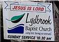
Lydbrook Baptist Church name sign, Lower Lydbrook
On the right here. http://www.geograph.org.uk/photo/4871011
Image: © Jaggery
Taken: 20 Mar 2016
0.07 miles