IMAGES TAKEN NEAR TO
Upper Lydbrook, LYDBROOK, GL17 9LG
Introduction
This page details the photographs taken nearby to GL17 9LG by members of the Geograph project.
The Geograph project started in 2005 with the aim of publishing, organising and preserving representative images for every square kilometre of Great Britain, Ireland and the Isle of Man.

There are currently over 7.5m images from over14,400 individuals and you can help contribute to the project by visiting https://www.geograph.org.uk
Image Map (Loading...)


Getting Data...Please wait
Leaflet Map data © OpenStreetMap
Images are licensed for reuse under creativecommons.org/licenses/by-sa/2.0
Notes
- Clicking on the map will re-center to the selected point.
- The higher the marker number, the further away the image location is from the centre of the postcode.
Image Listing (93 Images Found)
Images are licensed for reuse under creativecommons.org/licenses/by-sa/2.0
Image
Details
Distance
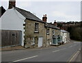
1
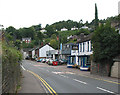
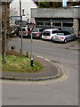
B4234 passing through Upper Lydbrook
The white building with blue window frames is the Jovial Colliers pub. Turn left after the pub for the church.
Image: © Pauline E
Taken: 14 Sep 2007
0.01 miles
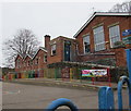
2
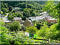
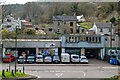
Upper Lydbrook
Viewed from New Road on a sunny August morning.
The brick building to the right is the Primary School.
Image: © Jonathan Billinger
Taken: 6 Aug 2009
0.01 miles
3
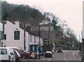
B4234 at The Jovial Colliers in Upper Lydbrook
Road has been prone to flooding here
Image: © Clint Mann
Taken: Unknown
0.05 miles
4
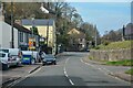
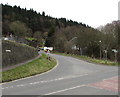
Lydbrook : B4234
Looking along the road.
Image: © Lewis Clarke
Taken: 22 Mar 2023
0.05 miles
5
Signpost on an Upper Lydbrook corner
The arm pointing up Church Road shows ½ (mile) to Joys Green, 1¾ to Ruardean.
Turn left onto the B4234 for Lydney (8 miles) or right for Ross-on-Wye (7).
Image: © Jaggery
Taken: 20 Mar 2016
0.06 miles
6
Lydbrook : Church Road
Looking along Church Road heading to the junction with the B4234.
Image: © Lewis Clarke
Taken: 22 Mar 2023
0.06 miles
7
Junction of Church Road and the B4234 in Lydbrook
Viewed across the B4234.
Image: © Jaggery
Taken: 20 Mar 2016
0.06 miles
8
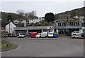
Lydbrook Tyres and Service Centre, Upper Lydbrook
Alongside the B4234, viewed from Church Road.
Image: © Jaggery
Taken: 20 Mar 2016
0.06 miles
9
Lydbrook Primary School, Lydbrook
Viewed from the School Road perimeter fence.
Image: © Jaggery
Taken: 20 Mar 2016
0.06 miles
10
Stone houses, Church Road, Lydbrook
Alongside the descent towards the B4234 junction.
Image: © Jaggery
Taken: 20 Mar 2016
0.07 miles