IMAGES TAKEN NEAR TO
Bridge Road, DRYBROOK, GL17 9JT
Introduction
This page details the photographs taken nearby to Bridge Road, GL17 9JT by members of the Geograph project.
The Geograph project started in 2005 with the aim of publishing, organising and preserving representative images for every square kilometre of Great Britain, Ireland and the Isle of Man.

There are currently over 7.5m images from over14,400 individuals and you can help contribute to the project by visiting https://www.geograph.org.uk
Image Map (Loading...)


Getting Data...Please wait
Leaflet Map data © OpenStreetMap
Images are licensed for reuse under creativecommons.org/licenses/by-sa/2.0
Notes
- Clicking on the map will re-center to the selected point.
- The higher the marker number, the further away the image location is from the centre of the postcode.
Image Listing (59 Images Found)
Images are licensed for reuse under creativecommons.org/licenses/by-sa/2.0
Image
Details
Distance
1
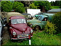
A collection of Minor importance
The red pick-up is badged as Austin, as some were in the late 1960's after the A35 van was discontinued.
The other three are worthy only as spares, according to the owner.
The lady in the green van has been sitting there for a while!
Image: © Jonathan Billinger
Taken: 9 Jun 2009
0.02 miles
2
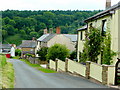
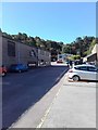
Bridge Road, Harrow Hill
Ex-quarryman's cottages on the steep hill down to the Drybrook valley bottom.
Ruardeanhill Plantation in the distance beyond.
Image: © Jonathan Billinger
Taken: 9 Jun 2009
0.05 miles
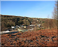
4
Houses above the east side of Drybrook Road, Drybrook
In the south of the village.
Image: © Jaggery
Taken: 11 Dec 2016
0.11 miles
5
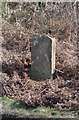
Old Milestone by Drybrook Road, Drybrook parish
Carved stone post by the UC road, in parish of Drybrook (Forest of Dean District), on approach to old railway bridge, on grass verge, on East side of road. Coleford stone, erected by the Forest of Dean turnpike trust in the 19th century.
Inscription once read:-
(Gloucester)
(13)
Milestone Society National ID: GL_COGL07
Image: © K Walker & R Harvey
Taken: 20 Mar 2004
0.11 miles
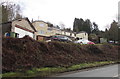
6
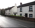
White houses in the south of Drybrook
On the west side of Drybrook Road.
Image: © Jaggery
Taken: 11 Dec 2016
0.11 miles
7
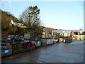
Hale's builders merchants
The part of the site concerned with building materials and aggregates. The forest is never far away.
Image: © Jonathan Billinger
Taken: 5 Jan 2008
0.11 miles
8
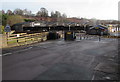
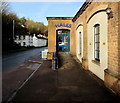
Entrance to Hale & Co (Drybrook) Ltd, Drybrook
Timber & Builders' Merchants premises set back from the corner of Morse Road and Drybrook Road.
Image: © Jaggery
Taken: 11 Dec 2016
0.11 miles
10
Hales office entrance, Morse Road, Drybrook
At the edge of this http://www.geograph.org.uk/photo/5223844 site.
Image: © Jaggery
Taken: 11 Dec 2016
0.13 miles