IMAGES TAKEN NEAR TO
Drybrook Road, DRYBROOK, GL17 9JE
Introduction
This page details the photographs taken nearby to Drybrook Road, GL17 9JE by members of the Geograph project.
The Geograph project started in 2005 with the aim of publishing, organising and preserving representative images for every square kilometre of Great Britain, Ireland and the Isle of Man.

There are currently over 7.5m images from over14,400 individuals and you can help contribute to the project by visiting https://www.geograph.org.uk
Image Map (Loading...)


Getting Data...Please wait
Leaflet Map data © OpenStreetMap
Images are licensed for reuse under creativecommons.org/licenses/by-sa/2.0
Notes
- Clicking on the map will re-center to the selected point.
- The higher the marker number, the further away the image location is from the centre of the postcode.
Image Listing (69 Images Found)
Images are licensed for reuse under creativecommons.org/licenses/by-sa/2.0
Image
Details
Distance
1

Drybrook Surgery, Drybrook
Medical surgery below the west side of Drybrook Road, near the Trinity Road junction. http://www.geograph.org.uk/photo/5224293
Image: © Jaggery
Taken: 11 Dec 2016
0.01 miles
2
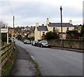
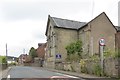
Direction signs opposite Trinity Road, Drybrook
Facing northbound traffic on Drybrook Road. Drybrook Surgery http://www.geograph.org.uk/photo/5224308 is below road level on the left.
For Harrow Hill, turn right into Trinity Road. http://www.geograph.org.uk/photo/5224293
Image: © Jaggery
Taken: 11 Dec 2016
0.01 miles
3
Drybrook Memorial Hall & Social Club
Drybrook Road
Image: © Pauline E
Taken: 18 Oct 2007
0.02 miles
4
Brick building on the north side of Drybrook Community Church, Drybrook
In December 2016, there is no name on this building next to Drybrook Community Church. http://www.geograph.org.uk/photo/5224372
Image: © Jaggery
Taken: 11 Dec 2016
0.03 miles
5
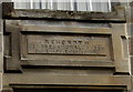
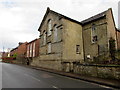
Inscription on Drybrook Community Church, Drybrook
Located between the four central windows here. http://www.geograph.org.uk/photo/5224372 The inscription records that the building was erected in 1858 as Rehoboth Congregational Church, enlarged in 1872.
Image: © Jaggery
Taken: 11 Dec 2016
0.03 miles
7
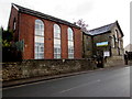
Drybrook Community Church, Drybrook
Viewed across Drybrook Road in December 2016. A notice on the gate on the left states that the service here is on every first and third Sunday each month, starting at 3pm. The inscription http://www.geograph.org.uk/photo/5224384 in stone between the four central windows records that the building was erected in 1858 as Rehoboth Congregational Church, enlarged in 1872.
Image: © Jaggery
Taken: 11 Dec 2016
0.04 miles
8

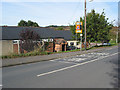
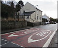
Start of the 30 zone in the south of Drybrook
On the approach to the centre of the village, the 40mph speed limit on Drybrook Road
drops to 30mph. Drybrook Community Church http://www.geograph.org.uk/photo/5224372 is on the right.
Image: © Jaggery
Taken: 11 Dec 2016
0.04 miles
9
From 30 to 40 on Drybrook Road, Drybrook
Near the southern edge of the village, the 30mph speed limit increases to 40mph.
Image: © Jaggery
Taken: 11 Dec 2016
0.04 miles
10
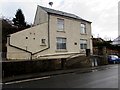
Redcliffe House, Drybrook
Drybrook Road house with a distinctive arrangement of drainpipes.
Image: © Jaggery
Taken: 11 Dec 2016
0.06 miles