IMAGES TAKEN NEAR TO
Drybrook Road, DRYBROOK, GL17 9JB
Introduction
This page details the photographs taken nearby to Drybrook Road, GL17 9JB by members of the Geograph project.
The Geograph project started in 2005 with the aim of publishing, organising and preserving representative images for every square kilometre of Great Britain, Ireland and the Isle of Man.

There are currently over 7.5m images from over14,400 individuals and you can help contribute to the project by visiting https://www.geograph.org.uk
Image Map (Loading...)


Getting Data...Please wait
Leaflet Map data © OpenStreetMap
Images are licensed for reuse under creativecommons.org/licenses/by-sa/2.0
Notes
- Clicking on the map will re-center to the selected point.
- The higher the marker number, the further away the image location is from the centre of the postcode.
Image Listing (99 Images Found)
Images are licensed for reuse under creativecommons.org/licenses/by-sa/2.0
Image
Details
Distance
1
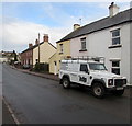
ADP Land Rover in Drybrook
Parked in Drybrook Road. Text on the side of the Land Rover shows that ADP's business includes land & utility surveying, diamond concrete coring, vacuum excavation, geo & environmental drilling, rotary borehole drilling.
ADP Group Ltd's head office is in Firing Close Farm, Wickwar near Wotton under Edge, Gloucestershire.
Image: © Jaggery
Taken: 11 Dec 2016
0.01 miles
2
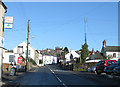
Drybrook Road
Looking north near the Hearts of Oak pub.
Image: © Pauline E
Taken: 18 Jan 2009
0.01 miles
3
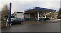
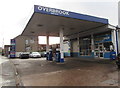
Overbrook Services, Drybrook
Garage, filling station and small shop alongside Drybrook Road.
Overbrook Services is on top of a culverted part of Dry Brook. http://www.geograph.org.uk/photo/5222250
Image: © Jaggery
Taken: 11 Dec 2016
0.02 miles
4

Dry Brook, Drybrook
Maps show that the brook named Dry Brook is fragmentary at surface level in the village. This fragment of Dry Brook emerges from a culvert near the village car park and disappears into another culvert behind the tree.
The culvert ahead is below the aptly named Overbrook Services (garage, filling station and small shop). http://www.geograph.org.uk/photo/5224246
Image: © Jaggery
Taken: 11 Dec 2016
0.02 miles
5
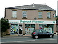
Drybrook Pharmacy
Situated on the main street, opposite Drybrook Garage Image
Image: © Jonathan Billinger
Taken: 9 Jun 2009
0.02 miles
6

Two semi-detached brick houses, Drybrook Road, Drybrook
Lancaster House is on the right.
Image: © Jaggery
Taken: 11 Dec 2016
0.02 miles
7

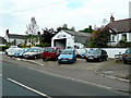
Village car park entrance, Drybrook
Free car park on the west side of Drybrook Road.
Image: © Jaggery
Taken: 11 Dec 2016
0.02 miles
8
Overbrook Services, Drybrook
Garage, filling station and small shop alongside Drybrook Road.
Overbrook Services is on top of a culverted part of Dry Brook. http://www.geograph.org.uk/photo/5222250
Image: © Jaggery
Taken: 11 Dec 2016
0.02 miles
9

Clothes and shoes recycling bins, Drybrook
In the Drybrook Recycling Site in a corner of the free village car park.
Image: © Jaggery
Taken: 11 Dec 2016
0.02 miles
10
Drybrook Garage
Situated on the main street of the village.
Image: © Jonathan Billinger
Taken: 9 Jun 2009
0.02 miles