IMAGES TAKEN NEAR TO
The Stenders, DRYBROOK, GL17 9EZ
Introduction
This page details the photographs taken nearby to The Stenders, GL17 9EZ by members of the Geograph project.
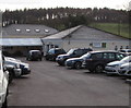
The Geograph project started in 2005 with the aim of publishing, organising and preserving representative images for every square kilometre of Great Britain, Ireland and the Isle of Man.

There are currently over 7.5m images from over14,400 individuals and you can help contribute to the project by visiting https://www.geograph.org.uk
Image Map (12 Images)


Getting Data...Please wait
Leaflet Map data © OpenStreetMap
Images are licensed for reuse under creativecommons.org/licenses/by-sa/2.0
Notes
- Clicking on the map will re-center to the selected point.
- The higher the marker number, the further away the image location is from the centre of the postcode.
Image Listing (12 Images Found)
Images are licensed for reuse under creativecommons.org/licenses/by-sa/2.0
Image
Details
Distance
1
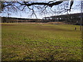
Pitches at Drybrook Rugby Club
Rugby is a popular sport in the Forest of Dean.
Image: © Stuart Wilding
Taken: 9 Feb 2006
0.14 miles
2
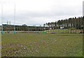
Saturday fixture at Drybrook RFC
Founded in 1892 and based at The Mannings, High Street, Drybrook.
Image: © Pauline E
Taken: 23 Feb 2008
0.14 miles
3
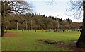
Juniors rugby match, Drybrook
Drybrook Rugby Club Juniors are playing a home match on Sunday December 11th 2016.
The location is the Mannings Ground, viewed from High Street, Drybrook.
Image: © Jaggery
Taken: 11 Dec 2016
0.20 miles
4
The clubhouse, Drybrook RFC
Founded 1892 and with lots of teams including a girls' team.
Image: © Pauline E
Taken: 23 Feb 2008
0.21 miles
5
Drybrook Rugby clubhouse, Drybrook
Drybrook Rugby Football Club's clubhouse is set back 60 metres from High Street,
at the edge of the club's Mannings Ground pitches.
Image: © Jaggery
Taken: 11 Dec 2016
0.22 miles
6
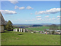
Sculptures at Wilderness Centre
Wilderness Centre is an educational establishment run by Gloucester County Council. One of the projects was erecting these sculptures which enhances the view towards the Malvern Hills.
Image: © charlie rigby
Taken: 8 Apr 2010
0.24 miles
7
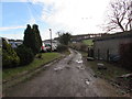
Road and public footpath towards Manning's Farm, Drybrook
A public footpath sign on the corner of High Street points this way.
Image: © Jaggery
Taken: 11 Dec 2016
0.24 miles
8
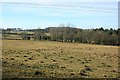
Very Dismantled Tramway
Marked on the map as a dismantled tramway. I thought there might be something to see, but nothing except a good collection of molehills.
Slightly more to see in this shot Image but tramway spotters needn't rush.
Image: © Des Blenkinsopp
Taken: 8 Feb 2015
0.24 miles
9
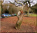
Wooden squirrel on a tree stump, Drybrook
At the edge of the Mannings Ground, the home of Drybrook Rugby Football Club.
A squirrel is featured in the club's name sign http://www.geograph.org.uk/photo/5236342 nearby.
Image: © Jaggery
Taken: 11 Dec 2016
0.24 miles
10
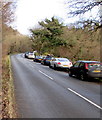
Unclassified road from Drybrook towards Mitcheldean
In the Forest of Dean District of west Gloucestershire.
Image: © Jaggery
Taken: 11 Dec 2016
0.24 miles