IMAGES TAKEN NEAR TO
Manse Road, DRYBROOK, GL17 9EH
Introduction
This page details the photographs taken nearby to Manse Road, GL17 9EH by members of the Geograph project.
The Geograph project started in 2005 with the aim of publishing, organising and preserving representative images for every square kilometre of Great Britain, Ireland and the Isle of Man.

There are currently over 7.5m images from over14,400 individuals and you can help contribute to the project by visiting https://www.geograph.org.uk
Image Map (Loading...)


Getting Data...Please wait
Leaflet Map data © OpenStreetMap
Images are licensed for reuse under creativecommons.org/licenses/by-sa/2.0
Notes
- Clicking on the map will re-center to the selected point.
- The higher the marker number, the further away the image location is from the centre of the postcode.
Image Listing (100 Images Found)
Images are licensed for reuse under creativecommons.org/licenses/by-sa/2.0
Image
Details
Distance
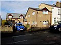
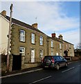
1
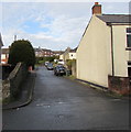
Manse Road, Drybrook
From High Street along Manse Road towards Hazel Road.
Image: © Jaggery
Taken: 11 Dec 2016
0.00 miles
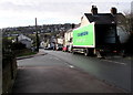
2
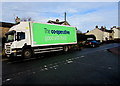
The Co-operative lorry in High Street, Drybrook
On a Sunday morning in December 2016, the lorry has brought stock for the nearby Co-op food shop. http://www.geograph.org.uk/photo/5222919
Image: © Jaggery
Taken: 11 Dec 2016
0.04 miles
3
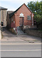
Meeting Room of Drybrook & District Male Voice Choir
Hawthorns Road, Drybrook.
Maybe it's a small choir?
The Methodist Church is behind this building.
Image: © Pauline E
Taken: 18 Oct 2007
0.04 miles
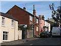
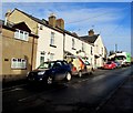
5
The Coach House, Drybrook
On the north side of High Street.
Image: © Jaggery
Taken: 11 Dec 2016
0.04 miles
6
Junction in High Street, Drybrook
From the left, the cul-de-sac named The Squirrels http://www.geograph.org.uk/photo/5222799 joins High Street.
The Co-op lorry has brought stock for the nearby Co-op food shop. http://www.geograph.org.uk/photo/5222919
Image: © Jaggery
Taken: 11 Dec 2016
0.04 miles
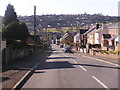
7
Up High Street, Drybrook
High Street ascends northeastwards away from The Cross, crossroads in the centre of the village.
A Co-op lorry is on the right. http://www.geograph.org.uk/photo/5222929
Image: © Jaggery
Taken: 11 Dec 2016
0.04 miles
8
High Street, Drybrook
View downhill of the High Street in Drybrook and also showing the village of Ruardean Hill in the distance.
Image: © Stuart Wilding
Taken: 9 Feb 2006
0.05 miles
9
Houses in Drybrook
Viewed across High Street.
Image: © Jaggery
Taken: 11 Dec 2016
0.05 miles
10
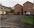
Two modern houses above Hawthorn Road, Drybrook
The houses have their garage built into the house, alongside the front door.
The name on the 3-storey house on the left is The Tall House,
a name which would also apply to its apparently unnamed neighbour on the right.
Image: © Jaggery
Taken: 11 Dec 2016
0.05 miles