IMAGES TAKEN NEAR TO
DRYBROOK, GL17 9DG
Introduction
This page details the photographs taken nearby to GL17 9DG by members of the Geograph project.
The Geograph project started in 2005 with the aim of publishing, organising and preserving representative images for every square kilometre of Great Britain, Ireland and the Isle of Man.

There are currently over 7.5m images from over14,400 individuals and you can help contribute to the project by visiting https://www.geograph.org.uk
Image Map (Loading...)


Getting Data...Please wait
Leaflet Map data © OpenStreetMap
Images are licensed for reuse under creativecommons.org/licenses/by-sa/2.0
Notes
- Clicking on the map will re-center to the selected point.
- The higher the marker number, the further away the image location is from the centre of the postcode.
Image Listing (24 Images Found)
Images are licensed for reuse under creativecommons.org/licenses/by-sa/2.0
Image
Details
Distance
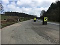
1
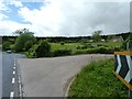
A4136 near Herbert Lodge
View of the turning to Herbert Lodge off the A4136 between Nailbridge and Brierley. Forest near Ruardean Walk visible in distance.
Image: © Clint Mann
Taken: 11 May 2014
0.09 miles
3
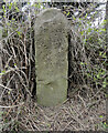
Old Milestone by the A4136 near Herbert Lodge
Carved stone post by the A4136, in parish of Drybrook (Forest of Dean District), by entrance to Herbert Lodge, by low wall, on North side of road. Coleford stone, erected by the Forest of Dean turnpike trust in the 19th century.
Inscription once read:-
(Gloucester)
(14)
Milestone Society National ID: GL_COGL06
Image: © Roadside Relics
Taken: 19 Apr 2024
0.12 miles
4
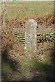
Old Milestone by the A4136 near Herbert Lodge
Carved stone post by the A4136, in parish of Drybrook (Forest of Dean District), by entrance to Herbert Lodge, by low wall, on North side of road. Coleford stone, erected by the Forest of Dean turnpike trust in the 19th century.
Inscription once read:-
(Gloucester)
(14)
Milestone Society National ID: GL_COGL06
Image: © K Walker & R Harvey
Taken: 20 Mar 2004
0.12 miles
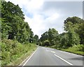
5
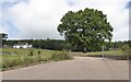
Lay-by off the A4136
Lay-by off the A4136 at Herbert Lodge
Image: © Shaun Ferguson
Taken: 14 Apr 2018
0.13 miles
6

Gale Stone, Ruardean Walk, Forest of Dean
Lain flat on the woods on Forestry (Crown) land affording pedestrian acces.
This was a coal mining rights marker, allocated by the "Verderers Court" of the Royal Forest in 1835.
Inscription: 92
Milestone Society National ID: GL_DRYBR04em
Image: © Mr Red
Taken: 19 Feb 2025
0.13 miles
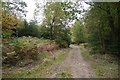
8
The Delves bus stop east of Brierley
A bus stop in the forest, serving paths into The Delves plantation
Image: © David Smith
Taken: 3 Aug 2018
0.20 miles
9

Enclosure Stone, A4136, Nailbridge, Forest of Dean
About 12m from the highway, the stone marks the edge of the Delves Inclosure (spellings vary), a subdivision of
the Royal Forest of Dean. The A R P defines the area enclosed, and was allocated by the "Verderers Court".
There is an OS rivet Benchmark on top which represents 567.2 ft Above Sea Level.
A context view of the area is Image, the stone is opposite the bus stop.
Inscription: 1844 / Delves E[nc.] / A. R. P / 57 5 0 / Lincoln C. Comm
Milestone Society National ID: GL_CIND13em
Image: © Mr Red
Taken: 19 Feb 2025
0.20 miles
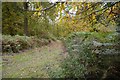
10
Ruardean Walk
A tramway to East Slade Colliery crossed this track here. Very little remains of the trackbed but a gully to the southeast shows up on orienteering maps.
Image: © Richard Webb
Taken: 19 Oct 2015
0.21 miles