IMAGES TAKEN NEAR TO
Hawkwell, DRYBROOK, GL17 9DA
Introduction
This page details the photographs taken nearby to Hawkwell, GL17 9DA by members of the Geograph project.
The Geograph project started in 2005 with the aim of publishing, organising and preserving representative images for every square kilometre of Great Britain, Ireland and the Isle of Man.

There are currently over 7.5m images from over14,400 individuals and you can help contribute to the project by visiting https://www.geograph.org.uk
Image Map (Loading...)


Getting Data...Please wait
Leaflet Map data © OpenStreetMap
Images are licensed for reuse under creativecommons.org/licenses/by-sa/2.0
Notes
- Clicking on the map will re-center to the selected point.
- The higher the marker number, the further away the image location is from the centre of the postcode.
Image Listing (32 Images Found)
Images are licensed for reuse under creativecommons.org/licenses/by-sa/2.0
Image
Details
Distance
1
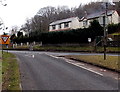
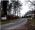
Give way in Hawkwell
The sign is alongside the A4151 at the western end of a triangular junction with the A4136.
The triangle is between the split northbound carriageway of the A4136.
One arm (this one) is for westbound traffic, the other arm for vehicles heading NE.
Image: © Jaggery
Taken: 24 Feb 2013
0.02 miles
2
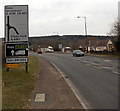
No Entry signs at a triangular junction, Hawkwell
At the junction of the A4151 and A4136 near the Hawkwell boundary sign. http://www.geograph.org.uk/photo/4152070
Image: © Jaggery
Taken: 24 Feb 2013
0.02 miles
3
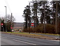
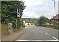
Red lights in Hawkwell
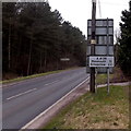
At the junction of the A4151 and A4136. A sign points right towards Ross(-on-Wye) and Gloucester.
Nearer locations shown are Drybrook, Ruardean and Mitcheldean.
Image: © Jaggery
Taken: 24 Feb 2013
0.03 miles
4
Hawkwell boundary sign
Alongside the A4136 in the Forest of Dean north of Cinderford.
Image: © Jaggery
Taken: 24 Feb 2013
0.03 miles
5
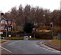
Split road splits again, Hawkwell
Behind the camera the A4151, the road north from Cinderford, has already split into two diverging carriageways, one for traffic from Cinderford (here), the other for traffic towards Cinderford.
Ahead, vehicles from Cinderford have the choice of the left fork for the Monmouth road via Coleford,
or the right fork for Ross-on-Wye or Gloucester.
Image: © Jaggery
Taken: 24 Feb 2013
0.03 miles
6
Nailbridge boundary sign
Alongside the A4136 north of Cinderford in the Forest of Dean.
Image: © Jaggery
Taken: 24 Feb 2013
0.04 miles
8
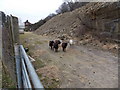
Nailbridge sheep
The sheep seemed to "appear from nowhere". They weren't here when I took this http://www.geograph.org.uk/photo/3832949 view of the nearby rocky outcrop less than a minute earlier.
Image: © Jaggery
Taken: 24 Feb 2013
0.05 miles
9
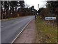
A4136 in Hawkwell 11 miles from Monmouth
A road in the Forest of Dean 11 miles from Monmouth and 27 from Chepstow.
Image: © Jaggery
Taken: 24 Feb 2013
0.07 miles
10
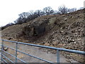
Rocky outcrop, Nailbridge
Alongside the A4136, at the edge of a disused quarry.
Image: © Jaggery
Taken: 24 Feb 2013
0.08 miles